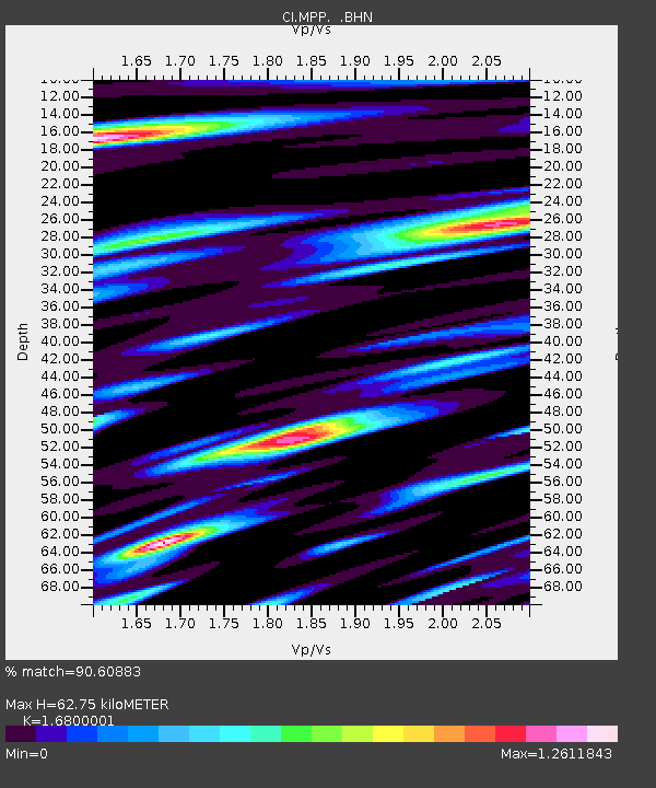
MPP McPhearson Peak - Earthquake Result Viewer
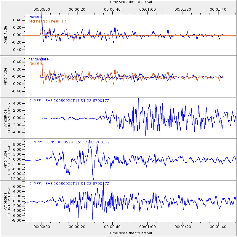
Earthquake location: Kermadec Islands, New Zealand
Earthquake latitude/longitude: -29.8/-177.7
Earthquake time(UTC): 2008/09/29 (273) 15:19:31 GMT
Earthquake Depth: 36 km
Earthquake Magnitude: 6.5 MB, 6.7 MS, 7.0 MW, 7.0 MW
Earthquake Catalog/Contributor: WHDF/NEIC
Network: CI Caltech Regional Seismic Network
Station: MPP McPhearson Peak
Lat/Lon: 34.89 N/119.81 W
Elevation: 1739 m
Distance: 84.3 deg
Az: 44.394 deg
Baz: 227.734 deg
Ray Param: 0.045519575
Estimated Moho Depth: 62.75 km
Estimated Crust Vp/Vs: 1.68
Assumed Crust Vp: 6.1 km/s
Estimated Crust Vs: 3.631 km/s
Estimated Crust Poisson's Ratio: 0.23
Radial Match: 90.60883 %
Radial Bump: 400
Transverse Match: 80.2945 %
Transverse Bump: 400
SOD ConfigId: 2560
Insert Time: 2010-02-26 02:03:13.043 +0000
GWidth: 2.5
Max Bumps: 400
Tol: 0.001

Signal To Noise

ChannelStoNSTALTA
CI:MPP: :BHN:20080929T15:31:28.670017Z3.84433257.146055E-71.8588547E-7
CI:MPP: :BHE:20080929T15:31:28.670017Z3.08592063.3340848E-71.0804183E-7
CI:MPP: :BHZ:20080929T15:31:28.670017Z1.37962852.8742645E-72.083361E-7
Arrivals
Ps7.2 SECOND
PpPs27 SECOND
PsPs/PpSs34 SECOND