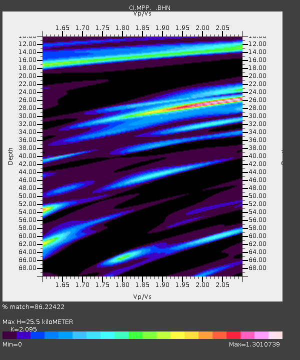
MPP McPhearson Peak - Earthquake Result Viewer
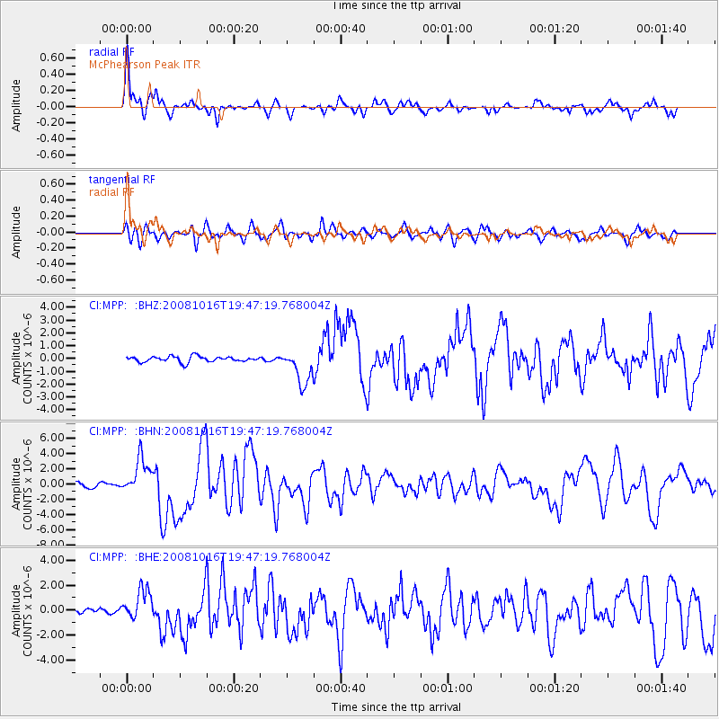
Earthquake location: Near Coast Of Chiapas, Mexico
Earthquake latitude/longitude: 14.4/-92.4
Earthquake time(UTC): 2008/10/16 (290) 19:41:25 GMT
Earthquake Depth: 24 km
Earthquake Magnitude: 6.1 MB, 6.6 MS, 6.7 MW, 6.6 MW
Earthquake Catalog/Contributor: WHDF/NEIC
Network: CI Caltech Regional Seismic Network
Station: MPP McPhearson Peak
Lat/Lon: 34.89 N/119.81 W
Elevation: 1739 m
Distance: 32.0 deg
Az: 314.402 deg
Baz: 122.643 deg
Ray Param: 0.07879519
Estimated Moho Depth: 25.5 km
Estimated Crust Vp/Vs: 2.10
Assumed Crust Vp: 6.1 km/s
Estimated Crust Vs: 2.912 km/s
Estimated Crust Poisson's Ratio: 0.35
Radial Match: 86.22422 %
Radial Bump: 400
Transverse Match: 67.18968 %
Transverse Bump: 400
SOD ConfigId: 2560
Insert Time: 2010-02-26 02:03:15.053 +0000
GWidth: 2.5
Max Bumps: 400
Tol: 0.001

Signal To Noise

ChannelStoNSTALTA
CI:MPP: :BHN:20081016T19:47:19.768004Z10.1130982.4017647E-62.3749053E-7
CI:MPP: :BHE:20081016T19:47:19.768004Z4.77574971.2126808E-62.5392472E-7
CI:MPP: :BHZ:20081016T19:47:19.768004Z6.15022331.3613725E-62.2135333E-7
Arrivals
Ps4.9 SECOND
PpPs12 SECOND
PsPs/PpSs17 SECOND