You are here: Home > Network List > TA - USArray Transportable Network (new EarthScope stations) Stations List
> Station D25K Kavik River, AK, USA > Earthquake Result Viewer
D25K Kavik River, AK, USA - Earthquake Result Viewer
| Earthquake location: |
Mindanao, Philippines |
| Earthquake latitude/longitude: |
5.9/125.2 |
| Earthquake time(UTC): |
2018/07/03 (184) 09:59:54 GMT |
| Earthquake Depth: |
100 km |
| Earthquake Magnitude: |
5.6 Mww |
| Earthquake Catalog/Contributor: |
NEIC PDE/us |
|
| Network: |
TA USArray Transportable Network (new EarthScope stations) |
| Station: |
D25K Kavik River, AK, USA |
| Lat/Lon: |
69.32 N/146.38 W |
| Elevation: |
770 m |
|
| Distance: |
84.0 deg |
| Az: |
20.918 deg |
| Baz: |
270.582 deg |
| Ray Param: |
0.045603655 |
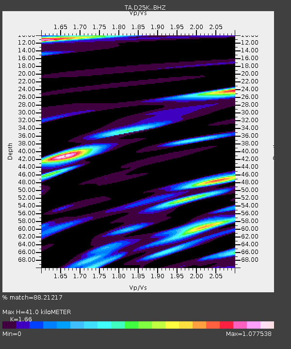
| Estimated Moho Depth: |
41.0 km |
| Estimated Crust Vp/Vs: |
1.66 |
| Assumed Crust Vp: |
6.378 km/s |
| Estimated Crust Vs: |
3.842 km/s |
| Estimated Crust Poisson's Ratio: |
0.22 |
|
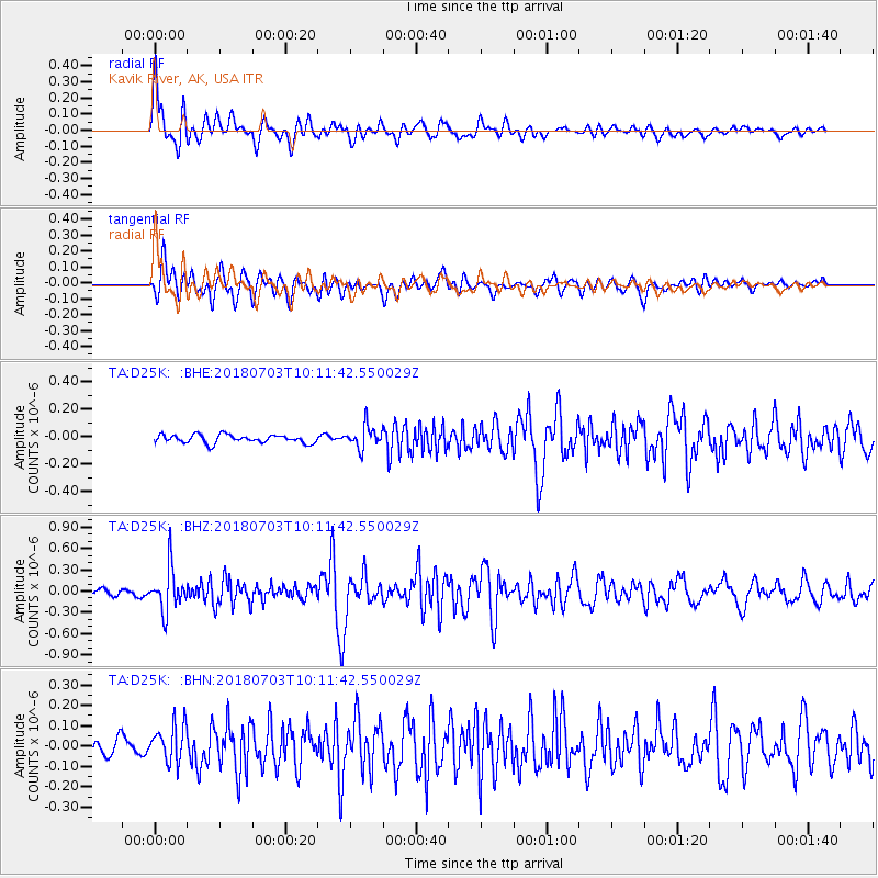
| Radial Match: |
88.21217 % |
| Radial Bump: |
400 |
| Transverse Match: |
77.75524 % |
| Transverse Bump: |
400 |
| SOD ConfigId: |
13570011 |
| Insert Time: |
2019-04-30 12:21:21.043 +0000 |
| GWidth: |
2.5 |
| Max Bumps: |
400 |
| Tol: |
0.001 |
|
Signal To Noise
| Channel | StoN | STA | LTA |
| TA:D25K: :BHZ:20180703T10:11:42.550029Z | 5.4679713 | 3.0336932E-7 | 5.548115E-8 |
| TA:D25K: :BHN:20180703T10:11:42.550029Z | 2.546933 | 9.1391875E-8 | 3.5883108E-8 |
| TA:D25K: :BHE:20180703T10:11:42.550029Z | 2.6647594 | 7.9789736E-8 | 2.9942566E-8 |
| Arrivals |
| Ps | 4.4 SECOND |
| PpPs | 17 SECOND |
| PsPs/PpSs | 21 SECOND |


