You are here: Home > Network List > TA - USArray Transportable Network (new EarthScope stations) Stations List
> Station G27K Doyon Strip, AK, USA > Earthquake Result Viewer
G27K Doyon Strip, AK, USA - Earthquake Result Viewer
| Earthquake location: |
Mindanao, Philippines |
| Earthquake latitude/longitude: |
5.9/125.2 |
| Earthquake time(UTC): |
2018/07/03 (184) 09:59:54 GMT |
| Earthquake Depth: |
100 km |
| Earthquake Magnitude: |
5.6 Mww |
| Earthquake Catalog/Contributor: |
NEIC PDE/us |
|
| Network: |
TA USArray Transportable Network (new EarthScope stations) |
| Station: |
G27K Doyon Strip, AK, USA |
| Lat/Lon: |
66.81 N/141.65 W |
| Elevation: |
686 m |
|
| Distance: |
85.9 deg |
| Az: |
23.359 deg |
| Baz: |
275.174 deg |
| Ray Param: |
0.044252053 |
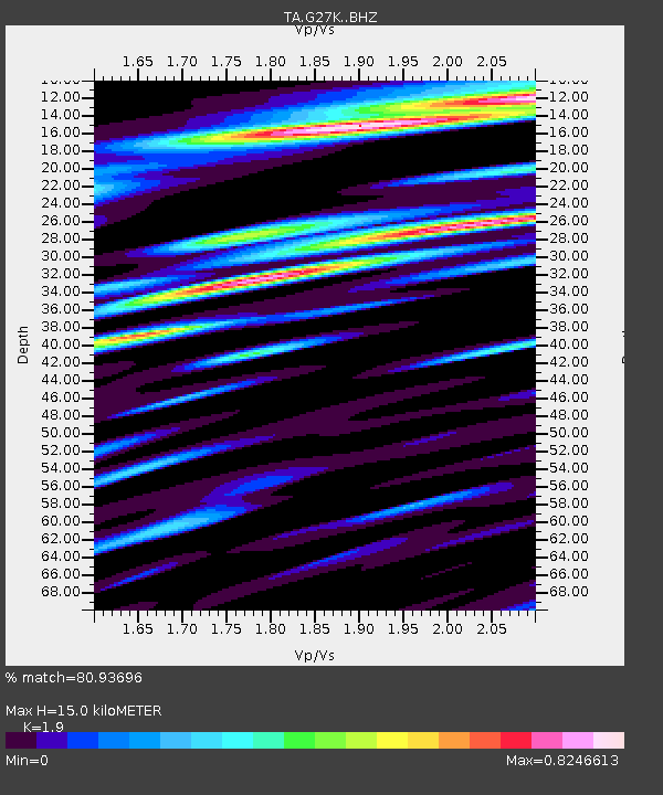
| Estimated Moho Depth: |
15.0 km |
| Estimated Crust Vp/Vs: |
1.90 |
| Assumed Crust Vp: |
6.577 km/s |
| Estimated Crust Vs: |
3.461 km/s |
| Estimated Crust Poisson's Ratio: |
0.31 |
|
| Radial Match: |
80.93696 % |
| Radial Bump: |
400 |
| Transverse Match: |
72.90399 % |
| Transverse Bump: |
400 |
| SOD ConfigId: |
13570011 |
| Insert Time: |
2019-04-30 12:21:44.870 +0000 |
| GWidth: |
2.5 |
| Max Bumps: |
400 |
| Tol: |
0.001 |
|

Signal To Noise
| Channel | StoN | STA | LTA |
| TA:G27K: :BHZ:20180703T10:11:51.99998Z | 3.776263 | 1.7718745E-7 | 4.6921375E-8 |
| TA:G27K: :BHN:20180703T10:11:51.99998Z | 1.993103 | 5.232527E-8 | 2.6253169E-8 |
| TA:G27K: :BHE:20180703T10:11:51.99998Z | 2.234735 | 7.036242E-8 | 3.14858E-8 |
| Arrivals |
| Ps | 2.1 SECOND |
| PpPs | 6.5 SECOND |
| PsPs/PpSs | 8.6 SECOND |


