You are here: Home > Network List > TA - USArray Transportable Network (new EarthScope stations) Stations List
> Station H23K Yukon River, AK, USA > Earthquake Result Viewer
H23K Yukon River, AK, USA - Earthquake Result Viewer
| Earthquake location: |
Mindanao, Philippines |
| Earthquake latitude/longitude: |
5.9/125.2 |
| Earthquake time(UTC): |
2018/07/03 (184) 09:59:54 GMT |
| Earthquake Depth: |
100 km |
| Earthquake Magnitude: |
5.6 Mww |
| Earthquake Catalog/Contributor: |
NEIC PDE/us |
|
| Network: |
TA USArray Transportable Network (new EarthScope stations) |
| Station: |
H23K Yukon River, AK, USA |
| Lat/Lon: |
65.83 N/149.54 W |
| Elevation: |
617 m |
|
| Distance: |
82.7 deg |
| Az: |
24.44 deg |
| Baz: |
268.064 deg |
| Ray Param: |
0.046484556 |
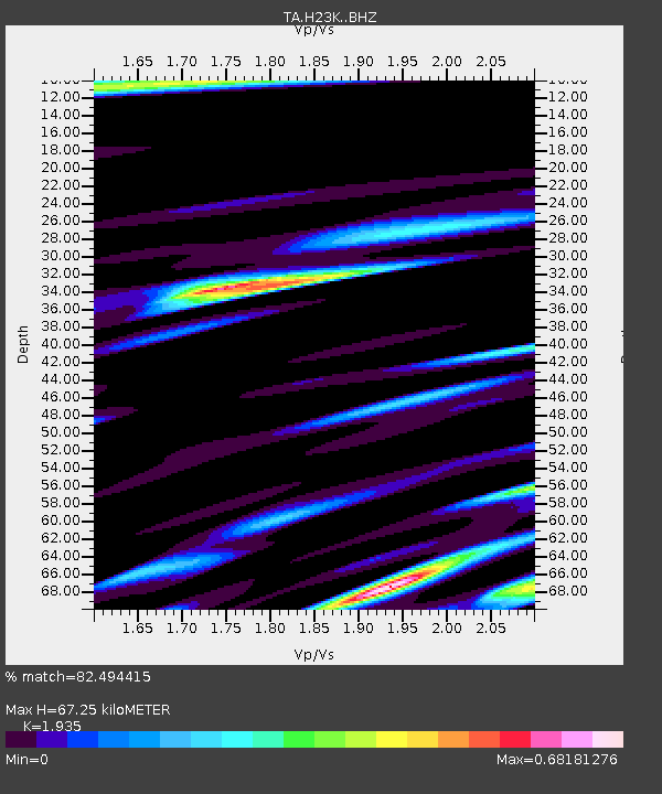
| Estimated Moho Depth: |
67.25 km |
| Estimated Crust Vp/Vs: |
1.93 |
| Assumed Crust Vp: |
6.566 km/s |
| Estimated Crust Vs: |
3.393 km/s |
| Estimated Crust Poisson's Ratio: |
0.32 |
|
| Radial Match: |
82.494415 % |
| Radial Bump: |
400 |
| Transverse Match: |
79.7341 % |
| Transverse Bump: |
400 |
| SOD ConfigId: |
13570011 |
| Insert Time: |
2019-04-30 12:21:50.725 +0000 |
| GWidth: |
2.5 |
| Max Bumps: |
400 |
| Tol: |
0.001 |
|

Signal To Noise
| Channel | StoN | STA | LTA |
| TA:H23K: :BHZ:20180703T10:11:36.12498Z | 7.7769766 | 3.410715E-7 | 4.385657E-8 |
| TA:H23K: :BHN:20180703T10:11:36.12498Z | 1.5303483 | 5.765206E-8 | 3.7672507E-8 |
| TA:H23K: :BHE:20180703T10:11:36.12498Z | 2.4927971 | 1.0048606E-7 | 4.0310564E-8 |
| Arrivals |
| Ps | 9.8 SECOND |
| PpPs | 29 SECOND |
| PsPs/PpSs | 39 SECOND |


