You are here: Home > Network List > TA - USArray Transportable Network (new EarthScope stations) Stations List
> Station J26L Joseph Creek, AK, USA > Earthquake Result Viewer
J26L Joseph Creek, AK, USA - Earthquake Result Viewer

| Earthquake location: |
Mindanao, Philippines |
| Earthquake latitude/longitude: |
5.9/125.2 |
| Earthquake time(UTC): |
2018/07/03 (184) 09:59:54 GMT |
| Earthquake Depth: |
100 km |
| Earthquake Magnitude: |
5.6 Mww |
| Earthquake Catalog/Contributor: |
NEIC PDE/us |
|
| Network: |
TA USArray Transportable Network (new EarthScope stations) |
| Station: |
J26L Joseph Creek, AK, USA |
| Lat/Lon: |
64.50 N/143.56 W |
| Elevation: |
1144 m |
|
| Distance: |
85.3 deg |
| Az: |
25.737 deg |
| Baz: |
273.621 deg |
| Ray Param: |
0.044685405 |
| Estimated Moho Depth: |
34.25 km |
| Estimated Crust Vp/Vs: |
1.84 |
| Assumed Crust Vp: |
6.566 km/s |
| Estimated Crust Vs: |
3.564 km/s |
| Estimated Crust Poisson's Ratio: |
0.29 |
|
| Radial Match: |
80.01072 % |
| Radial Bump: |
400 |
| Transverse Match: |
74.61441 % |
| Transverse Bump: |
400 |
| SOD ConfigId: |
13570011 |
| Insert Time: |
2019-04-30 12:22:05.609 +0000 |
| GWidth: |
2.5 |
| Max Bumps: |
400 |
| Tol: |
0.001 |
|
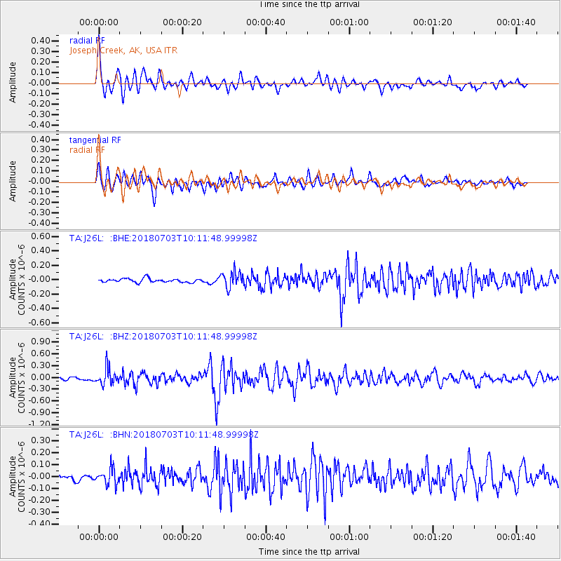
Signal To Noise
| Channel | StoN | STA | LTA |
| TA:J26L: :BHZ:20180703T10:11:48.99998Z | 4.4007945 | 2.128175E-7 | 4.835888E-8 |
| TA:J26L: :BHN:20180703T10:11:48.99998Z | 1.5959438 | 6.7831174E-8 | 4.250223E-8 |
| TA:J26L: :BHE:20180703T10:11:48.99998Z | 4.1696157 | 1.0945736E-7 | 2.6251188E-8 |
| Arrivals |
| Ps | 4.5 SECOND |
| PpPs | 14 SECOND |
| PsPs/PpSs | 19 SECOND |


