You are here: Home > Network List > TA - USArray Transportable Network (new EarthScope stations) Stations List
> Station M20K Styx River, AK, USA > Earthquake Result Viewer
M20K Styx River, AK, USA - Earthquake Result Viewer
| Earthquake location: |
Mindanao, Philippines |
| Earthquake latitude/longitude: |
5.9/125.2 |
| Earthquake time(UTC): |
2018/07/03 (184) 09:59:54 GMT |
| Earthquake Depth: |
100 km |
| Earthquake Magnitude: |
5.6 Mww |
| Earthquake Catalog/Contributor: |
NEIC PDE/us |
|
| Network: |
TA USArray Transportable Network (new EarthScope stations) |
| Station: |
M20K Styx River, AK, USA |
| Lat/Lon: |
61.88 N/153.13 W |
| Elevation: |
1107 m |
|
| Distance: |
80.9 deg |
| Az: |
28.339 deg |
| Baz: |
265.401 deg |
| Ray Param: |
0.047744382 |
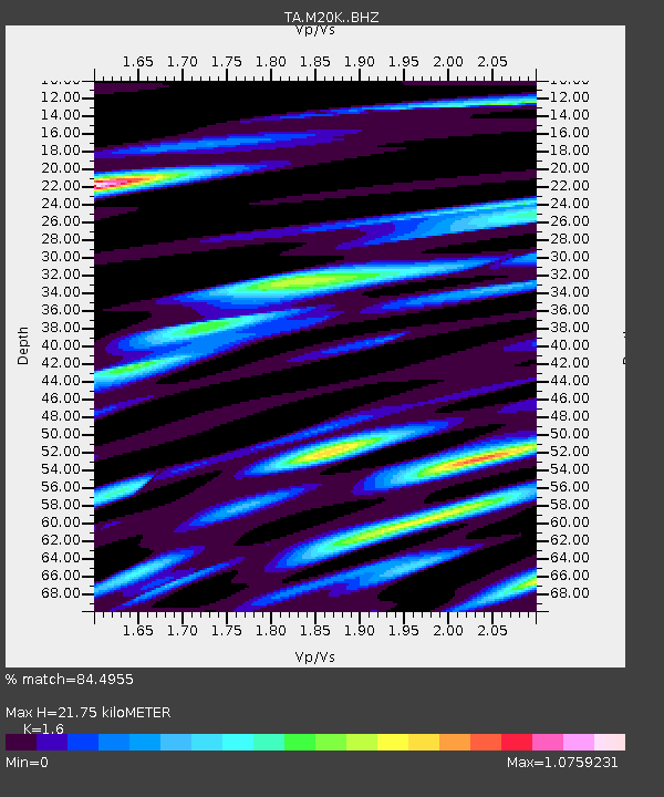
| Estimated Moho Depth: |
21.75 km |
| Estimated Crust Vp/Vs: |
1.60 |
| Assumed Crust Vp: |
6.566 km/s |
| Estimated Crust Vs: |
4.104 km/s |
| Estimated Crust Poisson's Ratio: |
0.18 |
|
| Radial Match: |
84.4955 % |
| Radial Bump: |
400 |
| Transverse Match: |
74.26599 % |
| Transverse Bump: |
400 |
| SOD ConfigId: |
13570011 |
| Insert Time: |
2019-04-30 12:22:24.910 +0000 |
| GWidth: |
2.5 |
| Max Bumps: |
400 |
| Tol: |
0.001 |
|

Signal To Noise
| Channel | StoN | STA | LTA |
| TA:M20K: :BHZ:20180703T10:11:26.650005Z | 4.5034013 | 3.6839413E-7 | 8.1803535E-8 |
| TA:M20K: :BHN:20180703T10:11:26.650005Z | 1.7536961 | 9.4328755E-8 | 5.3788543E-8 |
| TA:M20K: :BHE:20180703T10:11:26.650005Z | 2.5484242 | 1.2879207E-7 | 5.0537924E-8 |
| Arrivals |
| Ps | 2.1 SECOND |
| PpPs | 8.3 SECOND |
| PsPs/PpSs | 10 SECOND |


