You are here: Home > Network List > TA - USArray Transportable Network (new EarthScope stations) Stations List
> Station L18A Fontenelle, Green River, WY, USA > Earthquake Result Viewer
L18A Fontenelle, Green River, WY, USA - Earthquake Result Viewer
| Earthquake location: |
Colombia |
| Earthquake latitude/longitude: |
4.8/-75.5 |
| Earthquake time(UTC): |
2008/09/13 (257) 09:32:01 GMT |
| Earthquake Depth: |
133 km |
| Earthquake Magnitude: |
5.9 MB, 5.7 MW, 5.7 MW |
| Earthquake Catalog/Contributor: |
WHDF/NEIC |
|
| Network: |
TA USArray Transportable Network (new EarthScope stations) |
| Station: |
L18A Fontenelle, Green River, WY, USA |
| Lat/Lon: |
41.92 N/110.04 W |
| Elevation: |
2051 m |
|
| Distance: |
48.1 deg |
| Az: |
325.372 deg |
| Baz: |
130.637 deg |
| Ray Param: |
0.06911543 |
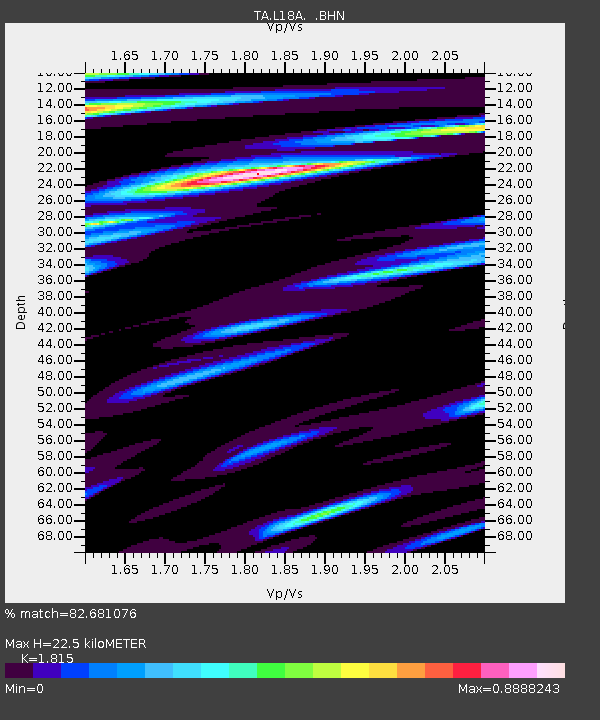
| Estimated Moho Depth: |
22.5 km |
| Estimated Crust Vp/Vs: |
1.82 |
| Assumed Crust Vp: |
6.155 km/s |
| Estimated Crust Vs: |
3.391 km/s |
| Estimated Crust Poisson's Ratio: |
0.28 |
|
| Radial Match: |
82.681076 % |
| Radial Bump: |
400 |
| Transverse Match: |
64.77264 % |
| Transverse Bump: |
400 |
| SOD ConfigId: |
2560 |
| Insert Time: |
2010-03-06 12:21:52.956 +0000 |
| GWidth: |
2.5 |
| Max Bumps: |
400 |
| Tol: |
0.001 |
|

Signal To Noise
| Channel | StoN | STA | LTA |
| TA:L18A: :BHN:20080913T09:39:57.17399Z | 20.607716 | 3.4739853E-6 | 1.6857693E-7 |
| TA:L18A: :BHE:20080913T09:39:57.17399Z | 4.9103403 | 9.873695E-7 | 2.0107964E-7 |
| TA:L18A: :BHZ:20080913T09:39:57.17399Z | 4.5317674 | 9.680259E-7 | 2.1360891E-7 |
| Arrivals |
| Ps | 3.1 SECOND |
| PpPs | 9.8 SECOND |
| PsPs/PpSs | 13 SECOND |


