You are here: Home > Network List > TA - USArray Transportable Network (new EarthScope stations) Stations List
> Station L18A Fontenelle, Green River, WY, USA > Earthquake Result Viewer
L18A Fontenelle, Green River, WY, USA - Earthquake Result Viewer
| Earthquake location: |
Near S. Coast Of Honshu, Japan |
| Earthquake latitude/longitude: |
33.2/137.9 |
| Earthquake time(UTC): |
2009/08/09 (221) 10:55:55 GMT |
| Earthquake Depth: |
297 km |
| Earthquake Magnitude: |
6.5 MB, 7.1 MW, 7.1 MW |
| Earthquake Catalog/Contributor: |
WHDF/NEIC |
|
| Network: |
TA USArray Transportable Network (new EarthScope stations) |
| Station: |
L18A Fontenelle, Green River, WY, USA |
| Lat/Lon: |
41.92 N/110.04 W |
| Elevation: |
2051 m |
|
| Distance: |
82.7 deg |
| Az: |
44.228 deg |
| Baz: |
308.373 deg |
| Ray Param: |
0.04596685 |
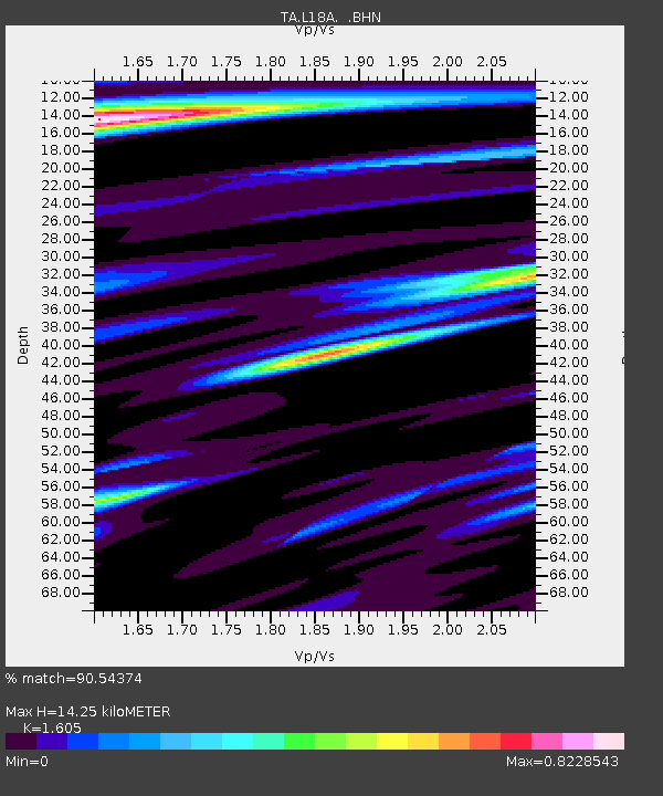
| Estimated Moho Depth: |
14.25 km |
| Estimated Crust Vp/Vs: |
1.61 |
| Assumed Crust Vp: |
6.155 km/s |
| Estimated Crust Vs: |
3.835 km/s |
| Estimated Crust Poisson's Ratio: |
0.18 |
|
| Radial Match: |
90.54374 % |
| Radial Bump: |
400 |
| Transverse Match: |
77.5984 % |
| Transverse Bump: |
400 |
| SOD ConfigId: |
2622 |
| Insert Time: |
2010-03-06 12:22:05.999 +0000 |
| GWidth: |
2.5 |
| Max Bumps: |
400 |
| Tol: |
0.001 |
|

Signal To Noise
| Channel | StoN | STA | LTA |
| TA:L18A: :BHN:20090809T11:07:14.950027Z | 115.81204 | 1.269935E-5 | 1.09654835E-7 |
| TA:L18A: :BHE:20090809T11:07:14.950027Z | 24.81196 | 1.9263632E-6 | 7.76385E-8 |
| TA:L18A: :BHZ:20090809T11:07:14.950027Z | 32.04157 | 2.4041105E-6 | 7.503099E-8 |
| Arrivals |
| Ps | 1.4 SECOND |
| PpPs | 5.9 SECOND |
| PsPs/PpSs | 7.3 SECOND |


