You are here: Home > Network List > TA - USArray Transportable Network (new EarthScope stations) Stations List
> Station L18A Fontenelle, Green River, WY, USA > Earthquake Result Viewer
L18A Fontenelle, Green River, WY, USA - Earthquake Result Viewer
| Earthquake location: |
North Of Honduras |
| Earthquake latitude/longitude: |
16.7/-86.2 |
| Earthquake time(UTC): |
2009/05/28 (148) 08:24:45 GMT |
| Earthquake Depth: |
10 km |
| Earthquake Magnitude: |
6.7 MB, 7.2 MS, 7.3 MW, 7.3 MW |
| Earthquake Catalog/Contributor: |
WHDF/NEIC |
|
| Network: |
TA USArray Transportable Network (new EarthScope stations) |
| Station: |
L18A Fontenelle, Green River, WY, USA |
| Lat/Lon: |
41.92 N/110.04 W |
| Elevation: |
2051 m |
|
| Distance: |
32.4 deg |
| Az: |
325.768 deg |
| Baz: |
133.75 deg |
| Ray Param: |
0.078680284 |
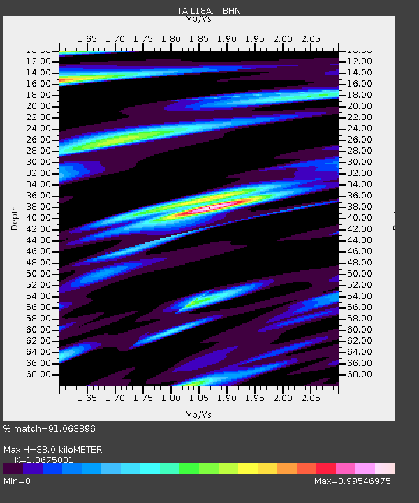
| Estimated Moho Depth: |
38.0 km |
| Estimated Crust Vp/Vs: |
1.87 |
| Assumed Crust Vp: |
6.155 km/s |
| Estimated Crust Vs: |
3.296 km/s |
| Estimated Crust Poisson's Ratio: |
0.30 |
|
| Radial Match: |
91.063896 % |
| Radial Bump: |
389 |
| Transverse Match: |
76.310486 % |
| Transverse Bump: |
400 |
| SOD ConfigId: |
2648 |
| Insert Time: |
2010-03-06 12:22:19.577 +0000 |
| GWidth: |
2.5 |
| Max Bumps: |
400 |
| Tol: |
0.001 |
|

Signal To Noise
| Channel | StoN | STA | LTA |
| TA:L18A: :BHN:20090528T08:30:43.948988Z | 24.770607 | 2.587662E-6 | 1.0446502E-7 |
| TA:L18A: :BHE:20090528T08:30:43.948988Z | 11.894341 | 1.0738212E-6 | 9.0280004E-8 |
| TA:L18A: :BHZ:20090528T08:30:43.948988Z | 18.532084 | 1.1155262E-6 | 6.019432E-8 |
| Arrivals |
| Ps | 5.7 SECOND |
| PpPs | 17 SECOND |
| PsPs/PpSs | 22 SECOND |


