You are here: Home > Network List > 5H - Central Virginia and South Carolina seismic monitoring experiment Stations List
> Station DAVE Dillwyn, VA > Earthquake Result Viewer
DAVE Dillwyn, VA - Earthquake Result Viewer
| Earthquake location: |
Near East Coast Of Kamchatka |
| Earthquake latitude/longitude: |
51.6/157.9 |
| Earthquake time(UTC): |
2018/07/06 (187) 01:40:08 GMT |
| Earthquake Depth: |
80 km |
| Earthquake Magnitude: |
6.1 Mwp |
| Earthquake Catalog/Contributor: |
NEIC PDE/us |
|
| Network: |
5H Central Virginia and South Carolina seismic monitoring experiment |
| Station: |
DAVE Dillwyn, VA |
| Lat/Lon: |
37.55 N/78.37 W |
| Elevation: |
130 m |
|
| Distance: |
78.5 deg |
| Az: |
42.385 deg |
| Baz: |
328.071 deg |
| Ray Param: |
0.04941279 |
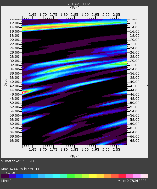
| Estimated Moho Depth: |
44.75 km |
| Estimated Crust Vp/Vs: |
1.60 |
| Assumed Crust Vp: |
6.419 km/s |
| Estimated Crust Vs: |
4.012 km/s |
| Estimated Crust Poisson's Ratio: |
0.18 |
|
| Radial Match: |
93.56393 % |
| Radial Bump: |
393 |
| Transverse Match: |
78.35306 % |
| Transverse Bump: |
400 |
| SOD ConfigId: |
13570011 |
| Insert Time: |
2019-04-30 12:29:39.367 +0000 |
| GWidth: |
2.5 |
| Max Bumps: |
400 |
| Tol: |
0.001 |
|

Signal To Noise
| Channel | StoN | STA | LTA |
| 5H:DAVE: :HHZ:20180706T01:51:30.630002Z | 22.869097 | 1.2885415E-6 | 5.6344227E-8 |
| 5H:DAVE: :HHN:20180706T01:51:30.630002Z | 7.4909434 | 3.447337E-7 | 4.6020062E-8 |
| 5H:DAVE: :HHE:20180706T01:51:30.630002Z | 6.1480737 | 2.3659933E-7 | 3.8483492E-8 |
| Arrivals |
| Ps | 4.3 SECOND |
| PpPs | 18 SECOND |
| PsPs/PpSs | 22 SECOND |


