You are here: Home > Network List > 5H - Central Virginia and South Carolina seismic monitoring experiment Stations List
> Station PTTI Yanceyville, VA > Earthquake Result Viewer
PTTI Yanceyville, VA - Earthquake Result Viewer
| Earthquake location: |
Near East Coast Of Kamchatka |
| Earthquake latitude/longitude: |
51.6/157.9 |
| Earthquake time(UTC): |
2018/07/06 (187) 01:40:08 GMT |
| Earthquake Depth: |
80 km |
| Earthquake Magnitude: |
6.1 Mwp |
| Earthquake Catalog/Contributor: |
NEIC PDE/us |
|
| Network: |
5H Central Virginia and South Carolina seismic monitoring experiment |
| Station: |
PTTI Yanceyville, VA |
| Lat/Lon: |
37.94 N/77.99 W |
| Elevation: |
98 m |
|
| Distance: |
78.4 deg |
| Az: |
41.912 deg |
| Baz: |
328.21 deg |
| Ray Param: |
0.0495268 |
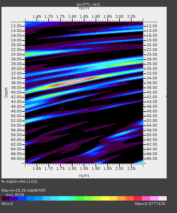
| Estimated Moho Depth: |
35.25 km |
| Estimated Crust Vp/Vs: |
1.80 |
| Assumed Crust Vp: |
6.565 km/s |
| Estimated Crust Vs: |
3.642 km/s |
| Estimated Crust Poisson's Ratio: |
0.28 |
|
| Radial Match: |
94.11031 % |
| Radial Bump: |
400 |
| Transverse Match: |
85.67688 % |
| Transverse Bump: |
400 |
| SOD ConfigId: |
13570011 |
| Insert Time: |
2019-04-30 12:29:55.879 +0000 |
| GWidth: |
2.5 |
| Max Bumps: |
400 |
| Tol: |
0.001 |
|

Signal To Noise
| Channel | StoN | STA | LTA |
| 5H:PTTI: :HHZ:20180706T01:51:29.705015Z | 22.29922 | 1.3916031E-6 | 6.240591E-8 |
| 5H:PTTI: :HHN:20180706T01:51:29.705015Z | 9.1470995 | 4.4680596E-7 | 4.8846733E-8 |
| 5H:PTTI: :HHE:20180706T01:51:29.705015Z | 3.3831708 | 1.2231696E-7 | 3.6154532E-8 |
| Arrivals |
| Ps | 4.4 SECOND |
| PpPs | 15 SECOND |
| PsPs/PpSs | 19 SECOND |


