You are here: Home > Network List > TA - USArray Transportable Network (new EarthScope stations) Stations List
> Station L18A Fontenelle, Green River, WY, USA > Earthquake Result Viewer
L18A Fontenelle, Green River, WY, USA - Earthquake Result Viewer
| Earthquake location: |
Panama |
| Earthquake latitude/longitude: |
9.6/-79.0 |
| Earthquake time(UTC): |
2009/07/04 (185) 06:49:35 GMT |
| Earthquake Depth: |
38 km |
| Earthquake Magnitude: |
6.0 MB, 5.5 MS, 6.0 MW, 6.0 MW |
| Earthquake Catalog/Contributor: |
WHDF/NEIC |
|
| Network: |
TA USArray Transportable Network (new EarthScope stations) |
| Station: |
L18A Fontenelle, Green River, WY, USA |
| Lat/Lon: |
41.92 N/110.04 W |
| Elevation: |
2051 m |
|
| Distance: |
42.2 deg |
| Az: |
325.032 deg |
| Baz: |
130.764 deg |
| Ray Param: |
0.07322087 |
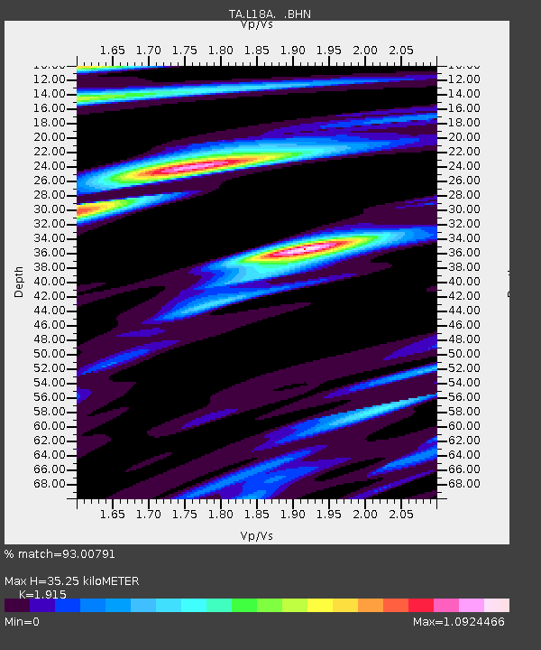
| Estimated Moho Depth: |
35.25 km |
| Estimated Crust Vp/Vs: |
1.91 |
| Assumed Crust Vp: |
6.155 km/s |
| Estimated Crust Vs: |
3.214 km/s |
| Estimated Crust Poisson's Ratio: |
0.31 |
|
| Radial Match: |
93.00791 % |
| Radial Bump: |
329 |
| Transverse Match: |
76.31649 % |
| Transverse Bump: |
400 |
| SOD ConfigId: |
2648 |
| Insert Time: |
2010-03-06 12:22:30.604 +0000 |
| GWidth: |
2.5 |
| Max Bumps: |
400 |
| Tol: |
0.001 |
|

Signal To Noise
| Channel | StoN | STA | LTA |
| TA:L18A: :BHN:20090704T06:56:54.400015Z | 18.270304 | 1.8243871E-6 | 9.985533E-8 |
| TA:L18A: :BHE:20090704T06:56:54.400015Z | 6.0773044 | 5.7810547E-7 | 9.5125316E-8 |
| TA:L18A: :BHZ:20090704T06:56:54.400015Z | 6.052532 | 4.7796453E-7 | 7.896935E-8 |
| Arrivals |
| Ps | 5.5 SECOND |
| PpPs | 16 SECOND |
| PsPs/PpSs | 21 SECOND |


