You are here: Home > Network List > TA - USArray Transportable Network (new EarthScope stations) Stations List
> Station L18A Fontenelle, Green River, WY, USA > Earthquake Result Viewer
L18A Fontenelle, Green River, WY, USA - Earthquake Result Viewer
| Earthquake location: |
South Of Fiji Islands |
| Earthquake latitude/longitude: |
-26.0/-177.5 |
| Earthquake time(UTC): |
2007/12/09 (343) 07:28:20 GMT |
| Earthquake Depth: |
152 km |
| Earthquake Magnitude: |
7.0 MB, 7.8 MW, 7.7 MW |
| Earthquake Catalog/Contributor: |
WHDF/NEIC |
|
| Network: |
TA USArray Transportable Network (new EarthScope stations) |
| Station: |
L18A Fontenelle, Green River, WY, USA |
| Lat/Lon: |
41.92 N/110.04 W |
| Elevation: |
2051 m |
|
| Distance: |
91.9 deg |
| Az: |
43.607 deg |
| Baz: |
236.283 deg |
| Ray Param: |
0.041473906 |
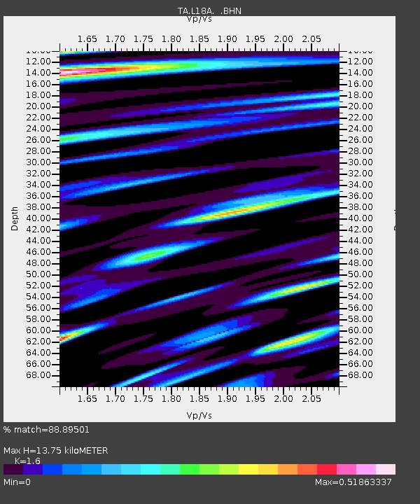
| Estimated Moho Depth: |
13.75 km |
| Estimated Crust Vp/Vs: |
1.60 |
| Assumed Crust Vp: |
6.155 km/s |
| Estimated Crust Vs: |
3.847 km/s |
| Estimated Crust Poisson's Ratio: |
0.18 |
|
| Radial Match: |
88.89501 % |
| Radial Bump: |
400 |
| Transverse Match: |
84.023155 % |
| Transverse Bump: |
400 |
| SOD ConfigId: |
2564 |
| Insert Time: |
2010-03-06 12:22:49.916 +0000 |
| GWidth: |
2.5 |
| Max Bumps: |
400 |
| Tol: |
0.001 |
|

Signal To Noise
| Channel | StoN | STA | LTA |
| TA:L18A: :BHN:20071209T07:40:40.475029Z | 1.2573432 | 3.1226017E-7 | 2.4834918E-7 |
| TA:L18A: :BHE:20071209T07:40:40.475029Z | 2.005167 | 4.421581E-7 | 2.2050936E-7 |
| TA:L18A: :BHZ:20071209T07:40:40.475029Z | 3.4274955 | 1.0188314E-6 | 2.9725246E-7 |
| Arrivals |
| Ps | 1.4 SECOND |
| PpPs | 5.7 SECOND |
| PsPs/PpSs | 7.1 SECOND |


