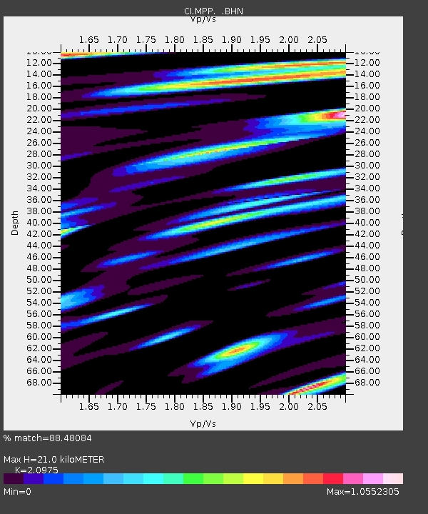
MPP McPhearson Peak - Earthquake Result Viewer
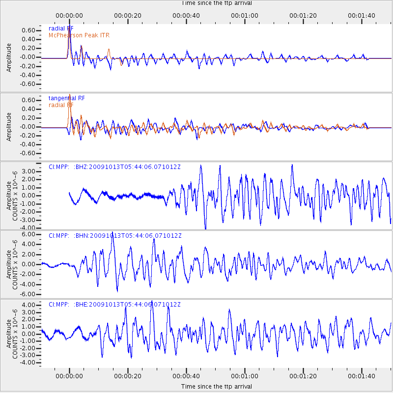
Earthquake location: Fox Islands, Aleutian Islands
Earthquake latitude/longitude: 52.8/-167.0
Earthquake time(UTC): 2009/10/13 (286) 05:37:23 GMT
Earthquake Depth: 24 km
Earthquake Magnitude: 6.0 MB, 6.1 MS, 6.5 MW, 6.5 MW
Earthquake Catalog/Contributor: WHDF/NEIC
Network: CI Caltech Regional Seismic Network
Station: MPP McPhearson Peak
Lat/Lon: 34.89 N/119.81 W
Elevation: 1739 m
Distance: 37.7 deg
Az: 99.192 deg
Baz: 313.124 deg
Ray Param: 0.075979955
Estimated Moho Depth: 21.0 km
Estimated Crust Vp/Vs: 2.10
Assumed Crust Vp: 6.1 km/s
Estimated Crust Vs: 2.908 km/s
Estimated Crust Poisson's Ratio: 0.35
Radial Match: 88.48084 %
Radial Bump: 400
Transverse Match: 83.030914 %
Transverse Bump: 400
SOD ConfigId: 2622
Insert Time: 2010-02-26 02:03:33.582 +0000
GWidth: 2.5
Max Bumps: 400
Tol: 0.001

Signal To Noise

ChannelStoNSTALTA
CI:MPP: :BHN:20091013T05:44:06.071012Z2.19626389.377094E-74.2695663E-7
CI:MPP: :BHE:20091013T05:44:06.071012Z1.12838056.5325713E-75.7893334E-7
CI:MPP: :BHZ:20091013T05:44:06.071012Z0.98048173.9803987E-74.0596362E-7
Arrivals
Ps4.0 SECOND
PpPs10 SECOND
PsPs/PpSs14 SECOND