You are here: Home > Network List > CN - Canadian National Seismograph Network Stations List
> Station MALO Mcalpine Lake, ON, CA > Earthquake Result Viewer
MALO Mcalpine Lake, ON, CA - Earthquake Result Viewer
| Earthquake location: |
Near East Coast Of Kamchatka |
| Earthquake latitude/longitude: |
51.6/157.9 |
| Earthquake time(UTC): |
2018/07/06 (187) 01:40:08 GMT |
| Earthquake Depth: |
80 km |
| Earthquake Magnitude: |
6.1 Mwp |
| Earthquake Catalog/Contributor: |
NEIC PDE/us |
|
| Network: |
CN Canadian National Seismograph Network |
| Station: |
MALO Mcalpine Lake, ON, CA |
| Lat/Lon: |
50.02 N/79.76 W |
| Elevation: |
271 m |
|
| Distance: |
67.5 deg |
| Az: |
36.115 deg |
| Baz: |
325.264 deg |
| Ray Param: |
0.056697298 |
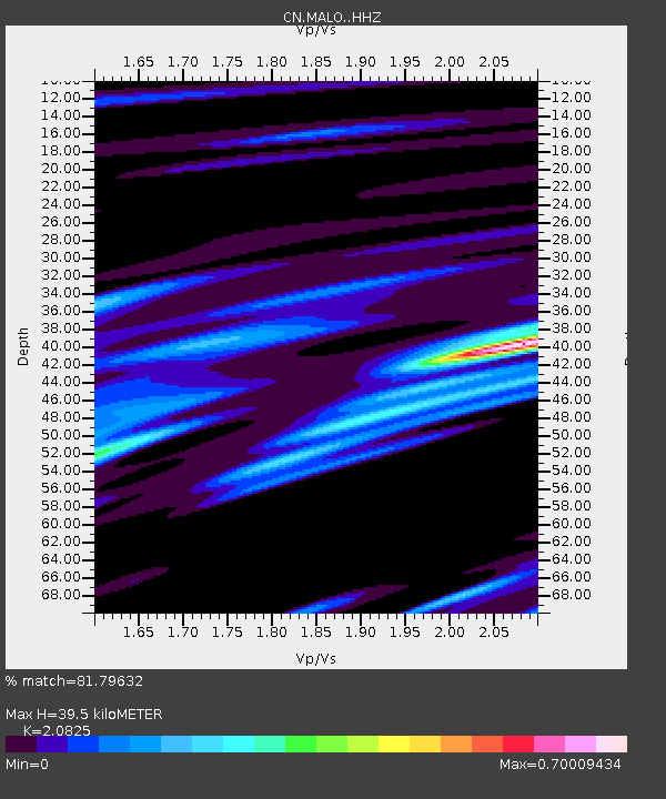
| Estimated Moho Depth: |
39.5 km |
| Estimated Crust Vp/Vs: |
2.08 |
| Assumed Crust Vp: |
6.459 km/s |
| Estimated Crust Vs: |
3.102 km/s |
| Estimated Crust Poisson's Ratio: |
0.35 |
|
| Radial Match: |
81.79632 % |
| Radial Bump: |
400 |
| Transverse Match: |
86.69602 % |
| Transverse Bump: |
400 |
| SOD ConfigId: |
13570011 |
| Insert Time: |
2019-04-30 12:33:45.637 +0000 |
| GWidth: |
2.5 |
| Max Bumps: |
400 |
| Tol: |
0.001 |
|

Signal To Noise
| Channel | StoN | STA | LTA |
| CN:MALO: :HHZ:20180706T01:50:26.020017Z | 11.332274 | 1.3943504E-6 | 1.2304243E-7 |
| CN:MALO: :HHN:20180706T01:50:26.020017Z | 3.5752308 | 3.3643047E-7 | 9.410035E-8 |
| CN:MALO: :HHE:20180706T01:50:26.020017Z | 5.215471 | 5.906572E-7 | 1.1325099E-7 |
| Arrivals |
| Ps | 6.8 SECOND |
| PpPs | 18 SECOND |
| PsPs/PpSs | 25 SECOND |


