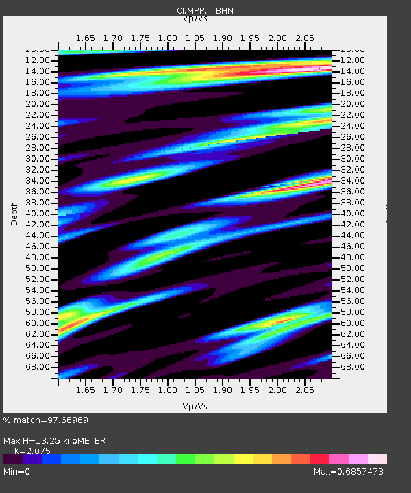
MPP McPhearson Peak - Earthquake Result Viewer
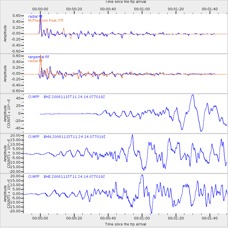
Earthquake location: Kuril Islands
Earthquake latitude/longitude: 46.6/153.3
Earthquake time(UTC): 2006/11/15 (319) 11:14:13 GMT
Earthquake Depth: 10 km
Earthquake Magnitude: 6.5 MB, 7.8 MS, 8.3 MW, 7.9 MW
Earthquake Catalog/Contributor: WHDF/NEIC
Network: CI Caltech Regional Seismic Network
Station: MPP McPhearson Peak
Lat/Lon: 34.89 N/119.81 W
Elevation: 1739 m
Distance: 63.7 deg
Az: 66.28 deg
Baz: 309.823 deg
Ray Param: 0.05939567
Estimated Moho Depth: 13.25 km
Estimated Crust Vp/Vs: 2.08
Assumed Crust Vp: 6.1 km/s
Estimated Crust Vs: 2.94 km/s
Estimated Crust Poisson's Ratio: 0.35
Radial Match: 97.66969 %
Radial Bump: 393
Transverse Match: 93.035934 %
Transverse Bump: 400
SOD ConfigId: 2564
Insert Time: 2010-02-26 02:03:38.325 +0000
GWidth: 2.5
Max Bumps: 400
Tol: 0.001

Signal To Noise

ChannelStoNSTALTA
CI:MPP: :BHN:20061115T11:24:14.077019Z1.5059917.9095787E-75.252076E-7
CI:MPP: :BHE:20061115T11:24:14.077019Z2.30567311.0729512E-64.653527E-7
CI:MPP: :BHZ:20061115T11:24:14.077019Z4.4060791.3708107E-63.1111801E-7
Arrivals
Ps2.4 SECOND
PpPs6.5 SECOND
PsPs/PpSs8.9 SECOND