You are here: Home > Network List > KR - Kyrgyz Digital Network Stations List
> Station DRK Karamyk, Kyrgyzstan > Earthquake Result Viewer
DRK Karamyk, Kyrgyzstan - Earthquake Result Viewer
| Earthquake location: |
Near East Coast Of Kamchatka |
| Earthquake latitude/longitude: |
51.6/157.9 |
| Earthquake time(UTC): |
2018/07/06 (187) 01:40:08 GMT |
| Earthquake Depth: |
80 km |
| Earthquake Magnitude: |
6.1 Mwp |
| Earthquake Catalog/Contributor: |
NEIC PDE/us |
|
| Network: |
KR Kyrgyz Digital Network |
| Station: |
DRK Karamyk, Kyrgyzstan |
| Lat/Lon: |
39.48 N/71.80 E |
| Elevation: |
2627 m |
|
| Distance: |
58.1 deg |
| Az: |
294.583 deg |
| Baz: |
47.108 deg |
| Ray Param: |
0.06283847 |
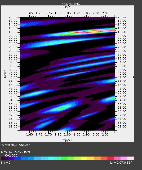
| Estimated Moho Depth: |
17.25 km |
| Estimated Crust Vp/Vs: |
2.01 |
| Assumed Crust Vp: |
6.306 km/s |
| Estimated Crust Vs: |
3.145 km/s |
| Estimated Crust Poisson's Ratio: |
0.33 |
|
| Radial Match: |
87.54046 % |
| Radial Bump: |
400 |
| Transverse Match: |
63.373386 % |
| Transverse Bump: |
400 |
| SOD ConfigId: |
13570011 |
| Insert Time: |
2019-04-30 12:36:01.044 +0000 |
| GWidth: |
2.5 |
| Max Bumps: |
400 |
| Tol: |
0.001 |
|

Signal To Noise
| Channel | StoN | STA | LTA |
| KR:DRK: :BHZ:20180706T01:49:23.080015Z | 9.376549 | 7.4526463E-7 | 7.9481765E-8 |
| KR:DRK: :BHN:20180706T01:49:23.080015Z | 3.4635024 | 3.447955E-7 | 9.955111E-8 |
| KR:DRK: :BHE:20180706T01:49:23.080015Z | 2.7441072 | 3.1464108E-7 | 1.1466064E-7 |
| Arrivals |
| Ps | 2.9 SECOND |
| PpPs | 7.9 SECOND |
| PsPs/PpSs | 11 SECOND |


