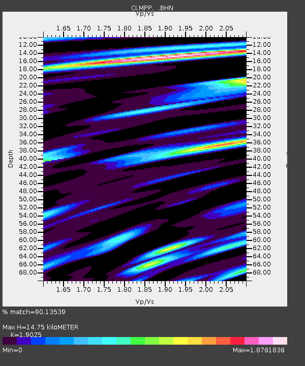
MPP McPhearson Peak - Earthquake Result Viewer
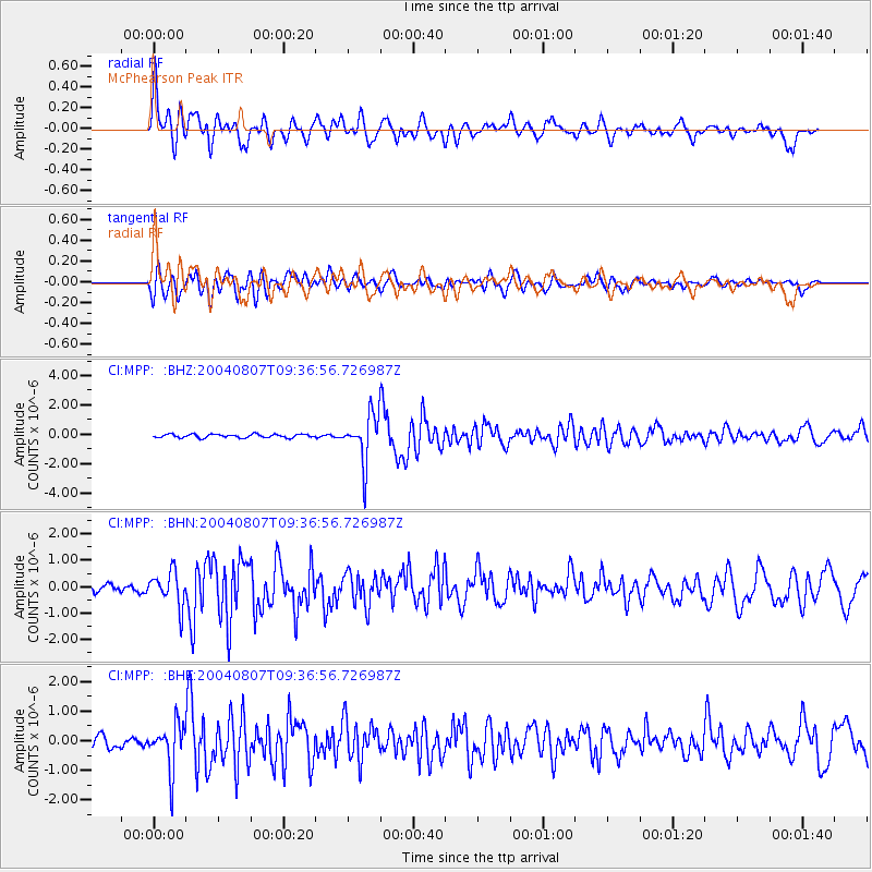
Earthquake location: South Of Aleutian Islands
Earthquake latitude/longitude: 51.8/-166.3
Earthquake time(UTC): 2004/08/07 (220) 09:30:16 GMT
Earthquake Depth: 8.0 km
Earthquake Magnitude: 6.3 MB, 5.4 MS, 6.0 MW, 6.0 MW
Earthquake Catalog/Contributor: WHDF/NEIC
Network: CI Caltech Regional Seismic Network
Station: MPP McPhearson Peak
Lat/Lon: 34.89 N/119.81 W
Elevation: 1739 m
Distance: 37.1 deg
Az: 98.519 deg
Baz: 311.598 deg
Ray Param: 0.07633496
Estimated Moho Depth: 14.75 km
Estimated Crust Vp/Vs: 1.90
Assumed Crust Vp: 6.1 km/s
Estimated Crust Vs: 3.206 km/s
Estimated Crust Poisson's Ratio: 0.31
Radial Match: 90.13539 %
Radial Bump: 400
Transverse Match: 73.810356 %
Transverse Bump: 400
SOD ConfigId: 2459
Insert Time: 2010-02-26 02:03:41.388 +0000
GWidth: 2.5
Max Bumps: 400
Tol: 0.001

Signal To Noise

ChannelStoNSTALTA
CI:MPP: :BHN:20040807T09:36:56.726987Z4.8984116.381173E-71.3027027E-7
CI:MPP: :BHE:20040807T09:36:56.726987Z4.2941857.726234E-71.7992318E-7
CI:MPP: :BHZ:20040807T09:36:56.726987Z13.6492381.6204536E-61.1872119E-7
Arrivals
Ps2.3 SECOND
PpPs6.6 SECOND
PsPs/PpSs8.9 SECOND