You are here: Home > Network List > N4 - Central and EAstern US Network Stations List
> Station G62A West of Eustis, ME, USA > Earthquake Result Viewer
G62A West of Eustis, ME, USA - Earthquake Result Viewer
| Earthquake location: |
Near East Coast Of Kamchatka |
| Earthquake latitude/longitude: |
51.6/157.9 |
| Earthquake time(UTC): |
2018/07/06 (187) 01:40:08 GMT |
| Earthquake Depth: |
80 km |
| Earthquake Magnitude: |
6.1 Mwp |
| Earthquake Catalog/Contributor: |
NEIC PDE/us |
|
| Network: |
N4 Central and EAstern US Network |
| Station: |
G62A West of Eustis, ME, USA |
| Lat/Lon: |
45.22 N/70.53 W |
| Elevation: |
426 m |
|
| Distance: |
74.9 deg |
| Az: |
33.182 deg |
| Baz: |
331.129 deg |
| Ray Param: |
0.0518454 |
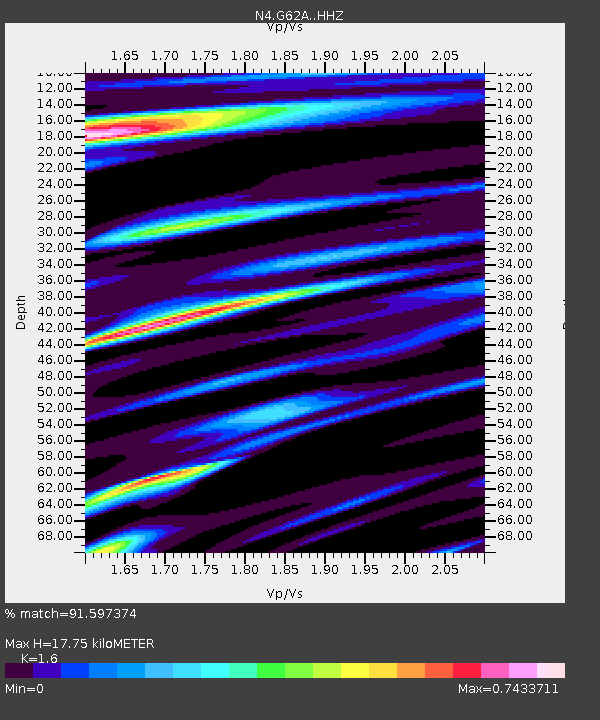
| Estimated Moho Depth: |
17.75 km |
| Estimated Crust Vp/Vs: |
1.60 |
| Assumed Crust Vp: |
6.419 km/s |
| Estimated Crust Vs: |
4.012 km/s |
| Estimated Crust Poisson's Ratio: |
0.18 |
|
| Radial Match: |
91.597374 % |
| Radial Bump: |
400 |
| Transverse Match: |
86.68379 % |
| Transverse Bump: |
400 |
| SOD ConfigId: |
13570011 |
| Insert Time: |
2019-04-30 12:37:27.813 +0000 |
| GWidth: |
2.5 |
| Max Bumps: |
400 |
| Tol: |
0.001 |
|

Signal To Noise
| Channel | StoN | STA | LTA |
| N4:G62A: :HHZ:20180706T01:51:10.380002Z | 16.567238 | 2.181809E-6 | 1.316942E-7 |
| N4:G62A: :HHN:20180706T01:51:10.380002Z | 6.4997225 | 5.459383E-7 | 8.3994095E-8 |
| N4:G62A: :HHE:20180706T01:51:10.380002Z | 5.9638104 | 5.242542E-7 | 8.790591E-8 |
| Arrivals |
| Ps | 1.7 SECOND |
| PpPs | 6.9 SECOND |
| PsPs/PpSs | 8.7 SECOND |


