You are here: Home > Network List > N4 - Central and EAstern US Network Stations List
> Station R49A Shelbyville, KY, USA > Earthquake Result Viewer
R49A Shelbyville, KY, USA - Earthquake Result Viewer
| Earthquake location: |
Near East Coast Of Kamchatka |
| Earthquake latitude/longitude: |
51.6/157.9 |
| Earthquake time(UTC): |
2018/07/06 (187) 01:40:08 GMT |
| Earthquake Depth: |
80 km |
| Earthquake Magnitude: |
6.1 Mwp |
| Earthquake Catalog/Contributor: |
NEIC PDE/us |
|
| Network: |
N4 Central and EAstern US Network |
| Station: |
R49A Shelbyville, KY, USA |
| Lat/Lon: |
38.29 N/85.17 W |
| Elevation: |
251 m |
|
| Distance: |
74.9 deg |
| Az: |
46.572 deg |
| Baz: |
324.867 deg |
| Ray Param: |
0.051826254 |
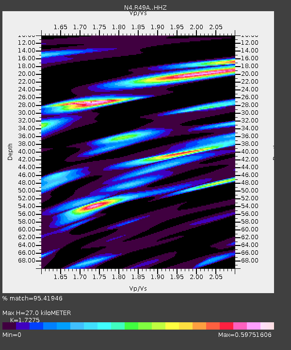
| Estimated Moho Depth: |
27.0 km |
| Estimated Crust Vp/Vs: |
1.73 |
| Assumed Crust Vp: |
6.498 km/s |
| Estimated Crust Vs: |
3.761 km/s |
| Estimated Crust Poisson's Ratio: |
0.25 |
|
| Radial Match: |
95.41946 % |
| Radial Bump: |
400 |
| Transverse Match: |
85.24061 % |
| Transverse Bump: |
400 |
| SOD ConfigId: |
13570011 |
| Insert Time: |
2019-04-30 12:38:22.088 +0000 |
| GWidth: |
2.5 |
| Max Bumps: |
400 |
| Tol: |
0.001 |
|

Signal To Noise
| Channel | StoN | STA | LTA |
| N4:R49A: :HHZ:20180706T01:51:10.46002Z | 36.956657 | 2.0762295E-6 | 5.6180127E-8 |
| N4:R49A: :HHN:20180706T01:51:10.46002Z | 11.579511 | 7.6896777E-7 | 6.640762E-8 |
| N4:R49A: :HHE:20180706T01:51:10.46002Z | 7.3899107 | 5.05588E-7 | 6.841598E-8 |
| Arrivals |
| Ps | 3.1 SECOND |
| PpPs | 11 SECOND |
| PsPs/PpSs | 14 SECOND |


