You are here: Home > Network List > N4 - Central and EAstern US Network Stations List
> Station T57A Hurt, VA, USA > Earthquake Result Viewer
T57A Hurt, VA, USA - Earthquake Result Viewer
| Earthquake location: |
Near East Coast Of Kamchatka |
| Earthquake latitude/longitude: |
51.6/157.9 |
| Earthquake time(UTC): |
2018/07/06 (187) 01:40:08 GMT |
| Earthquake Depth: |
80 km |
| Earthquake Magnitude: |
6.1 Mwp |
| Earthquake Catalog/Contributor: |
NEIC PDE/us |
|
| Network: |
N4 Central and EAstern US Network |
| Station: |
T57A Hurt, VA, USA |
| Lat/Lon: |
37.00 N/79.25 W |
| Elevation: |
230 m |
|
| Distance: |
78.6 deg |
| Az: |
43.294 deg |
| Baz: |
327.718 deg |
| Ray Param: |
0.04935029 |
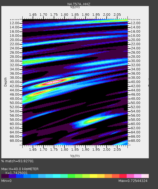
| Estimated Moho Depth: |
40.0 km |
| Estimated Crust Vp/Vs: |
1.74 |
| Assumed Crust Vp: |
6.419 km/s |
| Estimated Crust Vs: |
3.684 km/s |
| Estimated Crust Poisson's Ratio: |
0.25 |
|
| Radial Match: |
93.92781 % |
| Radial Bump: |
351 |
| Transverse Match: |
85.15496 % |
| Transverse Bump: |
400 |
| SOD ConfigId: |
13570011 |
| Insert Time: |
2019-04-30 12:38:35.526 +0000 |
| GWidth: |
2.5 |
| Max Bumps: |
400 |
| Tol: |
0.001 |
|

Signal To Noise
| Channel | StoN | STA | LTA |
| N4:T57A: :HHZ:20180706T01:51:31.130002Z | 16.541046 | 1.2460663E-6 | 7.533177E-8 |
| N4:T57A: :HHN:20180706T01:51:31.130002Z | 7.873191 | 3.98622E-7 | 5.0630298E-8 |
| N4:T57A: :HHE:20180706T01:51:31.130002Z | 5.079282 | 2.7237795E-7 | 5.362529E-8 |
| Arrivals |
| Ps | 4.8 SECOND |
| PpPs | 17 SECOND |
| PsPs/PpSs | 21 SECOND |


