You are here: Home > Network List > N4 - Central and EAstern US Network Stations List
> Station Y49A Blount Mountain, AL, USA > Earthquake Result Viewer
Y49A Blount Mountain, AL, USA - Earthquake Result Viewer
| Earthquake location: |
Near East Coast Of Kamchatka |
| Earthquake latitude/longitude: |
51.6/157.9 |
| Earthquake time(UTC): |
2018/07/06 (187) 01:40:08 GMT |
| Earthquake Depth: |
80 km |
| Earthquake Magnitude: |
6.1 Mwp |
| Earthquake Catalog/Contributor: |
NEIC PDE/us |
|
| Network: |
N4 Central and EAstern US Network |
| Station: |
Y49A Blount Mountain, AL, USA |
| Lat/Lon: |
33.86 N/86.41 W |
| Elevation: |
362 m |
|
| Distance: |
78.0 deg |
| Az: |
50.033 deg |
| Baz: |
324.951 deg |
| Ray Param: |
0.049781006 |
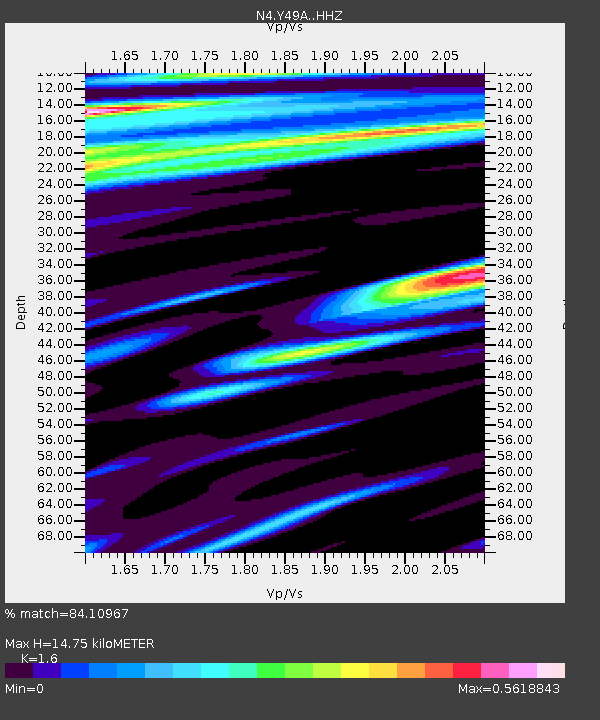
| Estimated Moho Depth: |
14.75 km |
| Estimated Crust Vp/Vs: |
1.60 |
| Assumed Crust Vp: |
6.565 km/s |
| Estimated Crust Vs: |
4.103 km/s |
| Estimated Crust Poisson's Ratio: |
0.18 |
|
| Radial Match: |
84.10967 % |
| Radial Bump: |
400 |
| Transverse Match: |
70.583496 % |
| Transverse Bump: |
400 |
| SOD ConfigId: |
13570011 |
| Insert Time: |
2019-04-30 12:38:51.134 +0000 |
| GWidth: |
2.5 |
| Max Bumps: |
400 |
| Tol: |
0.001 |
|

Signal To Noise
| Channel | StoN | STA | LTA |
| N4:Y49A: :HHZ:20180706T01:51:27.580015Z | 12.175501 | 1.5140172E-6 | 1.2434948E-7 |
| N4:Y49A: :HHN:20180706T01:51:27.580015Z | 5.878386 | 3.5561314E-7 | 6.0495026E-8 |
| N4:Y49A: :HHE:20180706T01:51:27.580015Z | 2.783106 | 3.1412014E-7 | 1.1286676E-7 |
| Arrivals |
| Ps | 1.4 SECOND |
| PpPs | 5.6 SECOND |
| PsPs/PpSs | 7.0 SECOND |


