You are here: Home > Network List > NN - Western Great Basin/Eastern Sierra Nevada Stations List
> Station WDEM Washoe County DEM, Nevada > Earthquake Result Viewer
WDEM Washoe County DEM, Nevada - Earthquake Result Viewer
| Earthquake location: |
Near East Coast Of Kamchatka |
| Earthquake latitude/longitude: |
51.6/157.9 |
| Earthquake time(UTC): |
2018/07/06 (187) 01:40:08 GMT |
| Earthquake Depth: |
80 km |
| Earthquake Magnitude: |
6.1 Mwp |
| Earthquake Catalog/Contributor: |
NEIC PDE/us |
|
| Network: |
NN Western Great Basin/Eastern Sierra Nevada |
| Station: |
WDEM Washoe County DEM, Nevada |
| Lat/Lon: |
39.58 N/119.81 W |
| Elevation: |
1572 m |
|
| Distance: |
55.9 deg |
| Az: |
67.633 deg |
| Baz: |
311.741 deg |
| Ray Param: |
0.064257264 |
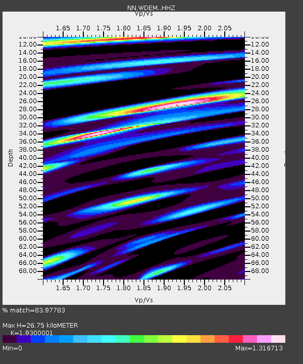
| Estimated Moho Depth: |
26.75 km |
| Estimated Crust Vp/Vs: |
1.93 |
| Assumed Crust Vp: |
6.279 km/s |
| Estimated Crust Vs: |
3.253 km/s |
| Estimated Crust Poisson's Ratio: |
0.32 |
|
| Radial Match: |
83.97783 % |
| Radial Bump: |
400 |
| Transverse Match: |
81.74902 % |
| Transverse Bump: |
400 |
| SOD ConfigId: |
13570011 |
| Insert Time: |
2019-04-30 12:39:31.993 +0000 |
| GWidth: |
2.5 |
| Max Bumps: |
400 |
| Tol: |
0.001 |
|

Signal To Noise
| Channel | StoN | STA | LTA |
| NN:WDEM: :HHZ:20180706T01:49:07.708005Z | 25.174757 | 2.6961793E-6 | 1.0709852E-7 |
| NN:WDEM: :HHN:20180706T01:49:07.708005Z | 18.550676 | 9.734971E-7 | 5.2477713E-8 |
| NN:WDEM: :HHE:20180706T01:49:07.708005Z | 4.260062 | 6.596648E-7 | 1.5484864E-7 |
| Arrivals |
| Ps | 4.1 SECOND |
| PpPs | 12 SECOND |
| PsPs/PpSs | 16 SECOND |


