You are here: Home > Network List > OH - Ohio Seismic Network Stations List
> Station LEBO Lake Erie Bluffs Ohio > Earthquake Result Viewer
LEBO Lake Erie Bluffs Ohio - Earthquake Result Viewer
| Earthquake location: |
Near East Coast Of Kamchatka |
| Earthquake latitude/longitude: |
51.6/157.9 |
| Earthquake time(UTC): |
2018/07/06 (187) 01:40:08 GMT |
| Earthquake Depth: |
80 km |
| Earthquake Magnitude: |
6.1 Mwp |
| Earthquake Catalog/Contributor: |
NEIC PDE/us |
|
| Network: |
OH Ohio Seismic Network |
| Station: |
LEBO Lake Erie Bluffs Ohio |
| Lat/Lon: |
41.79 N/81.18 W |
| Elevation: |
188 m |
|
| Distance: |
73.8 deg |
| Az: |
41.898 deg |
| Baz: |
326.166 deg |
| Ray Param: |
0.052583896 |
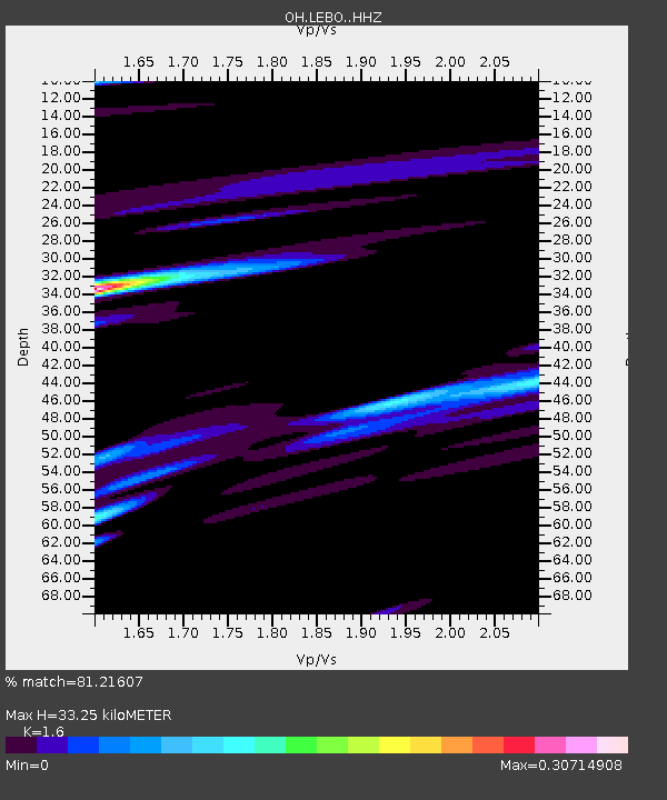
| Estimated Moho Depth: |
33.25 km |
| Estimated Crust Vp/Vs: |
1.60 |
| Assumed Crust Vp: |
6.483 km/s |
| Estimated Crust Vs: |
4.052 km/s |
| Estimated Crust Poisson's Ratio: |
0.18 |
|
| Radial Match: |
81.21607 % |
| Radial Bump: |
385 |
| Transverse Match: |
71.08749 % |
| Transverse Bump: |
400 |
| SOD ConfigId: |
13570011 |
| Insert Time: |
2019-04-30 12:39:55.451 +0000 |
| GWidth: |
2.5 |
| Max Bumps: |
400 |
| Tol: |
0.001 |
|

Signal To Noise
| Channel | StoN | STA | LTA |
| OH:LEBO: :HHZ:20180706T01:51:03.880002Z | 15.566176 | 2.6837613E-6 | 1.724098E-7 |
| OH:LEBO: :HHN:20180706T01:51:03.880002Z | 4.569126 | 9.0303155E-7 | 1.9763769E-7 |
| OH:LEBO: :HHE:20180706T01:51:03.880002Z | 2.9624994 | 6.877761E-7 | 2.3216074E-7 |
| Arrivals |
| Ps | 3.2 SECOND |
| PpPs | 13 SECOND |
| PsPs/PpSs | 16 SECOND |


