You are here: Home > Network List > OK - Oklahoma Seismic Network Stations List
> Station X37A Clayton, Oklahoma, USA > Earthquake Result Viewer
X37A Clayton, Oklahoma, USA - Earthquake Result Viewer
| Earthquake location: |
Near East Coast Of Kamchatka |
| Earthquake latitude/longitude: |
51.6/157.9 |
| Earthquake time(UTC): |
2018/07/06 (187) 01:40:08 GMT |
| Earthquake Depth: |
80 km |
| Earthquake Magnitude: |
6.1 Mwp |
| Earthquake Catalog/Contributor: |
NEIC PDE/us |
|
| Network: |
OK Oklahoma Seismic Network |
| Station: |
X37A Clayton, Oklahoma, USA |
| Lat/Lon: |
34.59 N/95.37 W |
| Elevation: |
207 m |
|
| Distance: |
72.9 deg |
| Az: |
55.716 deg |
| Baz: |
321.357 deg |
| Ray Param: |
0.05314992 |
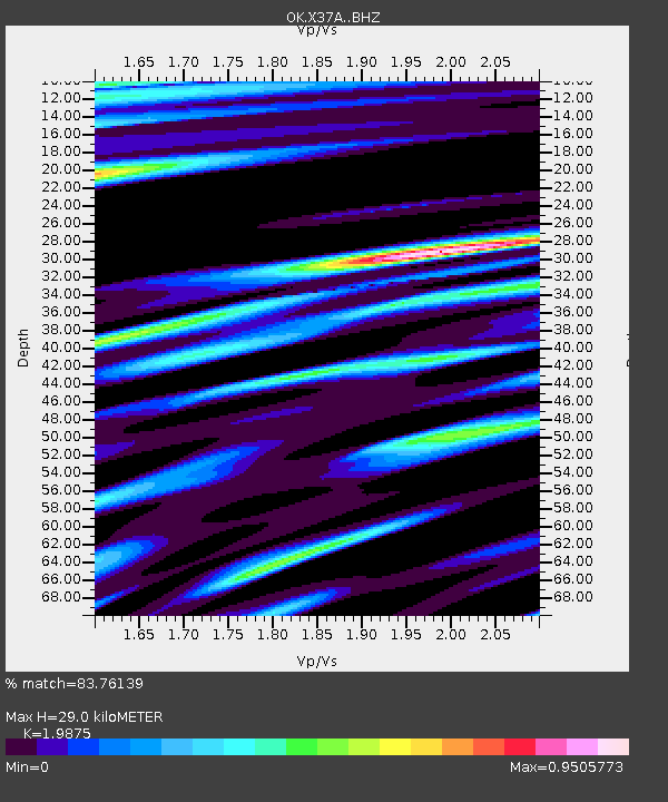
| Estimated Moho Depth: |
29.0 km |
| Estimated Crust Vp/Vs: |
1.99 |
| Assumed Crust Vp: |
6.498 km/s |
| Estimated Crust Vs: |
3.269 km/s |
| Estimated Crust Poisson's Ratio: |
0.33 |
|
| Radial Match: |
83.76139 % |
| Radial Bump: |
400 |
| Transverse Match: |
77.484085 % |
| Transverse Bump: |
400 |
| SOD ConfigId: |
13570011 |
| Insert Time: |
2019-04-30 12:40:11.339 +0000 |
| GWidth: |
2.5 |
| Max Bumps: |
400 |
| Tol: |
0.001 |
|

Signal To Noise
| Channel | StoN | STA | LTA |
| OK:X37A: :BHZ:20180706T01:50:58.775022Z | 12.567572 | 1.4217571E-6 | 1.13129026E-7 |
| OK:X37A: :BHN:20180706T01:50:58.775022Z | 4.0166206 | 4.1370274E-7 | 1.0299771E-7 |
| OK:X37A: :BHE:20180706T01:50:58.775022Z | 3.1813817 | 3.5653824E-7 | 1.12070246E-7 |
| Arrivals |
| Ps | 4.5 SECOND |
| PpPs | 13 SECOND |
| PsPs/PpSs | 17 SECOND |


