You are here: Home > Network List > PE - Penn State Network Stations List
> Station PACH Chapman State Park, Clarendon, PA > Earthquake Result Viewer
PACH Chapman State Park, Clarendon, PA - Earthquake Result Viewer
| Earthquake location: |
Near East Coast Of Kamchatka |
| Earthquake latitude/longitude: |
51.6/157.9 |
| Earthquake time(UTC): |
2018/07/06 (187) 01:40:08 GMT |
| Earthquake Depth: |
80 km |
| Earthquake Magnitude: |
6.1 Mwp |
| Earthquake Catalog/Contributor: |
NEIC PDE/us |
|
| Network: |
PE Penn State Network |
| Station: |
PACH Chapman State Park, Clarendon, PA |
| Lat/Lon: |
41.76 N/79.17 W |
| Elevation: |
431 m |
|
| Distance: |
74.6 deg |
| Az: |
40.61 deg |
| Baz: |
327.149 deg |
| Ray Param: |
0.05201459 |
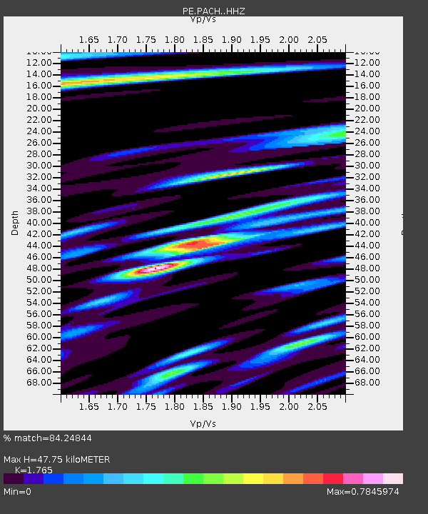
| Estimated Moho Depth: |
47.75 km |
| Estimated Crust Vp/Vs: |
1.76 |
| Assumed Crust Vp: |
6.121 km/s |
| Estimated Crust Vs: |
3.468 km/s |
| Estimated Crust Poisson's Ratio: |
0.26 |
|
| Radial Match: |
84.24844 % |
| Radial Bump: |
400 |
| Transverse Match: |
61.560596 % |
| Transverse Bump: |
400 |
| SOD ConfigId: |
13570011 |
| Insert Time: |
2019-04-30 12:40:31.347 +0000 |
| GWidth: |
2.5 |
| Max Bumps: |
400 |
| Tol: |
0.001 |
|

Signal To Noise
| Channel | StoN | STA | LTA |
| PE:PACH: :HHZ:20180706T01:51:08.82501Z | 21.567032 | 1.7542988E-6 | 8.134169E-8 |
| PE:PACH: :HHN:20180706T01:51:08.82501Z | 4.606255 | 6.6929573E-7 | 1.453015E-7 |
| PE:PACH: :HHE:20180706T01:51:08.82501Z | 2.4336617 | 5.111786E-7 | 2.1004506E-7 |
| Arrivals |
| Ps | 6.1 SECOND |
| PpPs | 21 SECOND |
| PsPs/PpSs | 27 SECOND |


