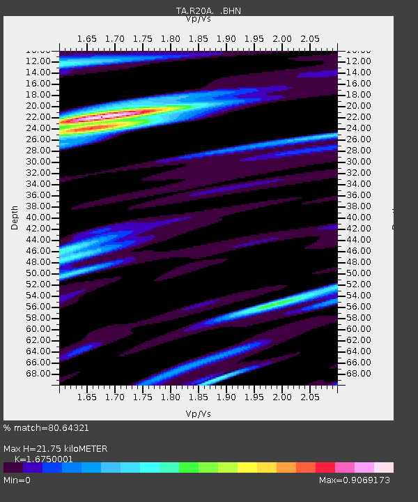
R20A Redvale, CO, USA - Earthquake Result Viewer
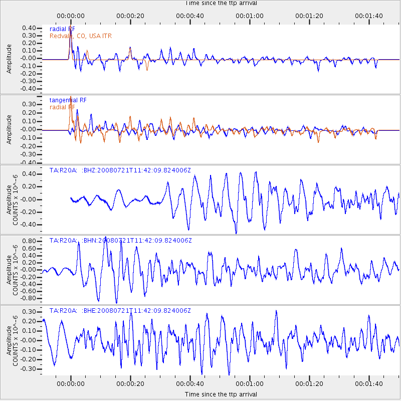
Earthquake location: Off East Coast Of Honshu, Japan
Earthquake latitude/longitude: 37.2/142.1
Earthquake time(UTC): 2008/07/21 (203) 11:30:29 GMT
Earthquake Depth: 22 km
Earthquake Magnitude: 5.7 MB, 5.6 MS, 6.0 MW, 5.9 MW
Earthquake Catalog/Contributor: WHDF/NEIC
Network: TA USArray Transportable Network (new EarthScope stations)
Station: R20A Redvale, CO, USA
Lat/Lon: 38.19 N/108.38 W
Elevation: 2003 m
Distance: 80.8 deg
Az: 48.775 deg
Baz: 310.334 deg
Ray Param: 0.048004154
Estimated Moho Depth: 21.75 km
Estimated Crust Vp/Vs: 1.68
Assumed Crust Vp: 6.291 km/s
Estimated Crust Vs: 3.756 km/s
Estimated Crust Poisson's Ratio: 0.22
Radial Match: 80.64321 %
Radial Bump: 373
Transverse Match: 68.14348 %
Transverse Bump: 400
SOD ConfigId: 2504
Insert Time: 2010-03-06 12:25:33.473 +0000
GWidth: 2.5
Max Bumps: 400
Tol: 0.001

Signal To Noise

ChannelStoNSTALTA
TA:R20A: :BHN:20080721T11:42:09.824006Z3.0676183.149275E-71.026619E-7
TA:R20A: :BHE:20080721T11:42:09.824006Z0.76834779.7013746E-81.2626283E-7
TA:R20A: :BHZ:20080721T11:42:09.824006Z2.32397131.5015328E-76.461064E-8
Arrivals
Ps2.4 SECOND
PpPs9.0 SECOND
PsPs/PpSs11 SECOND