You are here: Home > Network List > TA - USArray Transportable Network (new EarthScope stations) Stations List
> Station R20A Redvale, CO, USA > Earthquake Result Viewer
R20A Redvale, CO, USA - Earthquake Result Viewer
| Earthquake location: |
Virgin Islands |
| Earthquake latitude/longitude: |
19.2/-64.8 |
| Earthquake time(UTC): |
2008/10/11 (285) 10:40:14 GMT |
| Earthquake Depth: |
23 km |
| Earthquake Magnitude: |
6.1 MB, 5.9 MS, 6.1 MW, 6.0 MW |
| Earthquake Catalog/Contributor: |
WHDF/NEIC |
|
| Network: |
TA USArray Transportable Network (new EarthScope stations) |
| Station: |
R20A Redvale, CO, USA |
| Lat/Lon: |
38.19 N/108.38 W |
| Elevation: |
2003 m |
|
| Distance: |
42.2 deg |
| Az: |
306.085 deg |
| Baz: |
104.197 deg |
| Ray Param: |
0.073277034 |
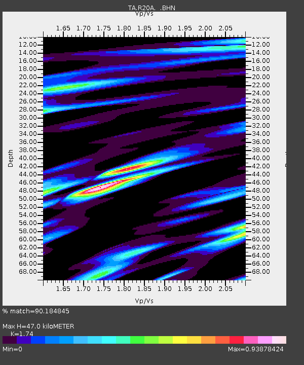
| Estimated Moho Depth: |
47.0 km |
| Estimated Crust Vp/Vs: |
1.74 |
| Assumed Crust Vp: |
6.291 km/s |
| Estimated Crust Vs: |
3.615 km/s |
| Estimated Crust Poisson's Ratio: |
0.25 |
|
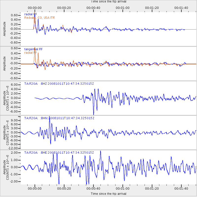
| Radial Match: |
90.184845 % |
| Radial Bump: |
400 |
| Transverse Match: |
75.757706 % |
| Transverse Bump: |
400 |
| SOD ConfigId: |
2556 |
| Insert Time: |
2010-03-06 12:25:54.522 +0000 |
| GWidth: |
2.5 |
| Max Bumps: |
400 |
| Tol: |
0.001 |
|
Signal To Noise
| Channel | StoN | STA | LTA |
| TA:R20A: :BHN:20081011T10:47:34.325015Z | 2.5858016 | 1.5630008E-6 | 6.0445507E-7 |
| TA:R20A: :BHE:20081011T10:47:34.325015Z | 1.4348786 | 2.9407676E-7 | 2.0494888E-7 |
| TA:R20A: :BHZ:20081011T10:47:34.325015Z | 4.322469 | 7.86323E-7 | 1.8191524E-7 |
| Arrivals |
| Ps | 5.9 SECOND |
| PpPs | 19 SECOND |
| PsPs/PpSs | 25 SECOND |


