You are here: Home > Network List > TA - USArray Transportable Network (new EarthScope stations) Stations List
> Station BGNE Belgrade, NE, USA > Earthquake Result Viewer
BGNE Belgrade, NE, USA - Earthquake Result Viewer
| Earthquake location: |
Near East Coast Of Kamchatka |
| Earthquake latitude/longitude: |
51.6/157.9 |
| Earthquake time(UTC): |
2018/07/06 (187) 01:40:08 GMT |
| Earthquake Depth: |
80 km |
| Earthquake Magnitude: |
6.1 Mwp |
| Earthquake Catalog/Contributor: |
NEIC PDE/us |
|
| Network: |
TA USArray Transportable Network (new EarthScope stations) |
| Station: |
BGNE Belgrade, NE, USA |
| Lat/Lon: |
41.41 N/98.15 W |
| Elevation: |
573 m |
|
| Distance: |
66.3 deg |
| Az: |
52.846 deg |
| Baz: |
318.649 deg |
| Ray Param: |
0.057498157 |
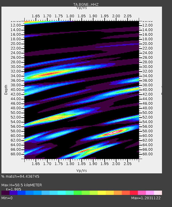
| Estimated Moho Depth: |
58.5 km |
| Estimated Crust Vp/Vs: |
1.99 |
| Assumed Crust Vp: |
6.53 km/s |
| Estimated Crust Vs: |
3.29 km/s |
| Estimated Crust Poisson's Ratio: |
0.33 |
|
| Radial Match: |
94.436745 % |
| Radial Bump: |
346 |
| Transverse Match: |
84.52383 % |
| Transverse Bump: |
400 |
| SOD ConfigId: |
13570011 |
| Insert Time: |
2019-04-30 12:42:14.441 +0000 |
| GWidth: |
2.5 |
| Max Bumps: |
400 |
| Tol: |
0.001 |
|

Signal To Noise
| Channel | StoN | STA | LTA |
| TA:BGNE: :HHZ:20180706T01:50:18.130002Z | 26.649948 | 3.3932495E-6 | 1.2732669E-7 |
| TA:BGNE: :HHN:20180706T01:50:18.130002Z | 7.870287 | 1.4377906E-6 | 1.8268591E-7 |
| TA:BGNE: :HHE:20180706T01:50:18.130002Z | 9.503913 | 1.4057946E-6 | 1.4791745E-7 |
| Arrivals |
| Ps | 9.2 SECOND |
| PpPs | 26 SECOND |
| PsPs/PpSs | 35 SECOND |


