You are here: Home > Network List > TA - USArray Transportable Network (new EarthScope stations) Stations List
> Station C26K Camden Bay, AK, USA > Earthquake Result Viewer
C26K Camden Bay, AK, USA - Earthquake Result Viewer
| Earthquake location: |
Near East Coast Of Kamchatka |
| Earthquake latitude/longitude: |
51.6/157.9 |
| Earthquake time(UTC): |
2018/07/06 (187) 01:40:08 GMT |
| Earthquake Depth: |
80 km |
| Earthquake Magnitude: |
6.1 Mwp |
| Earthquake Catalog/Contributor: |
NEIC PDE/us |
|
| Network: |
TA USArray Transportable Network (new EarthScope stations) |
| Station: |
C26K Camden Bay, AK, USA |
| Lat/Lon: |
69.92 N/144.91 W |
| Elevation: |
139 m |
|
| Distance: |
31.8 deg |
| Az: |
33.489 deg |
| Baz: |
264.915 deg |
| Ray Param: |
0.07874135 |
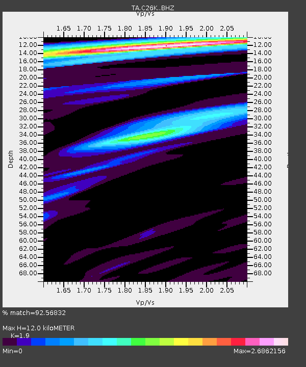
| Estimated Moho Depth: |
12.0 km |
| Estimated Crust Vp/Vs: |
1.90 |
| Assumed Crust Vp: |
6.455 km/s |
| Estimated Crust Vs: |
3.398 km/s |
| Estimated Crust Poisson's Ratio: |
0.31 |
|
| Radial Match: |
92.56832 % |
| Radial Bump: |
400 |
| Transverse Match: |
85.65045 % |
| Transverse Bump: |
400 |
| SOD ConfigId: |
13570011 |
| Insert Time: |
2019-04-30 12:42:15.167 +0000 |
| GWidth: |
2.5 |
| Max Bumps: |
400 |
| Tol: |
0.001 |
|

Signal To Noise
| Channel | StoN | STA | LTA |
| TA:C26K: :BHZ:20180706T01:45:55.149991Z | 21.394001 | 1.8687399E-6 | 8.734878E-8 |
| TA:C26K: :BHN:20180706T01:45:55.149991Z | 5.969862 | 4.907845E-7 | 8.221035E-8 |
| TA:C26K: :BHE:20180706T01:45:55.149991Z | 7.531004 | 5.6777935E-7 | 7.539226E-8 |
| Arrivals |
| Ps | 1.8 SECOND |
| PpPs | 5.0 SECOND |
| PsPs/PpSs | 6.8 SECOND |


