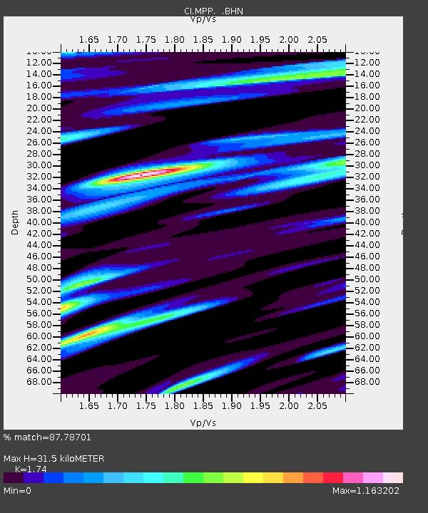
MPP McPhearson Peak - Earthquake Result Viewer
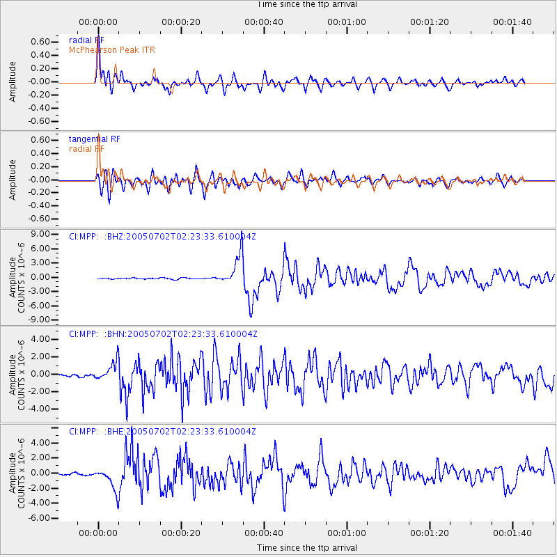
Earthquake location: Near Coast Of Nicaragua
Earthquake latitude/longitude: 11.2/-86.2
Earthquake time(UTC): 2005/07/02 (183) 02:16:43 GMT
Earthquake Depth: 27 km
Earthquake Magnitude: 5.6 MB, 6.4 MS, 6.6 MW, 6.6 MW
Earthquake Catalog/Contributor: WHDF/NEIC
Network: CI Caltech Regional Seismic Network
Station: MPP McPhearson Peak
Lat/Lon: 34.89 N/119.81 W
Elevation: 1739 m
Distance: 38.6 deg
Az: 313.089 deg
Baz: 119.362 deg
Ray Param: 0.07543362
Estimated Moho Depth: 31.5 km
Estimated Crust Vp/Vs: 1.74
Assumed Crust Vp: 6.1 km/s
Estimated Crust Vs: 3.506 km/s
Estimated Crust Poisson's Ratio: 0.25
Radial Match: 87.78701 %
Radial Bump: 400
Transverse Match: 74.81499 %
Transverse Bump: 400
SOD ConfigId: 2475
Insert Time: 2010-02-26 02:03:57.561 +0000
GWidth: 2.5
Max Bumps: 400
Tol: 0.001

Signal To Noise

ChannelStoNSTALTA
CI:MPP: :BHN:20050702T02:23:33.610004Z7.23250531.1076219E-61.5314497E-7
CI:MPP: :BHE:20050702T02:23:33.610004Z10.8470191.5514935E-61.4303409E-7
CI:MPP: :BHZ:20050702T02:23:33.610004Z27.2318973.4298432E-61.2594948E-7
Arrivals
Ps4.1 SECOND
PpPs13 SECOND
PsPs/PpSs17 SECOND