You are here: Home > Network List > TA - USArray Transportable Network (new EarthScope stations) Stations List
> Station R20A Redvale, CO, USA > Earthquake Result Viewer
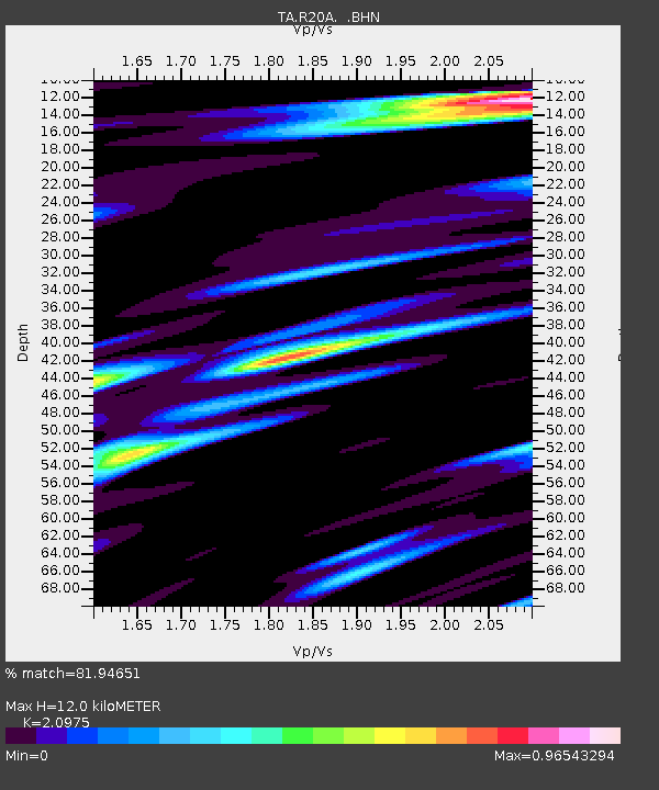
R20A Redvale, CO, USA - Earthquake Result Viewer
| Earthquake location: |
Central East Pacific Rise |
| Earthquake latitude/longitude: |
-4.6/-106.0 |
| Earthquake time(UTC): |
2008/09/18 (262) 01:41:02 GMT |
| Earthquake Depth: |
10 km |
| Earthquake Magnitude: |
5.5 MB, 5.7 MS, 6.0 MW, 6.0 MW |
| Earthquake Catalog/Contributor: |
WHDF/NEIC |
|
| Network: |
TA USArray Transportable Network (new EarthScope stations) |
| Station: |
R20A Redvale, CO, USA |
| Lat/Lon: |
38.19 N/108.38 W |
| Elevation: |
2003 m |
|
| Distance: |
42.6 deg |
| Az: |
357.229 deg |
| Baz: |
176.494 deg |
| Ray Param: |
0.07309082 |
| Estimated Moho Depth: |
12.0 km |
| Estimated Crust Vp/Vs: |
2.10 |
| Assumed Crust Vp: |
6.291 km/s |
| Estimated Crust Vs: |
2.999 km/s |
| Estimated Crust Poisson's Ratio: |
0.35 |
|
| Radial Match: |
81.94651 % |
| Radial Bump: |
400 |
| Transverse Match: |
58.46183 % |
| Transverse Bump: |
387 |
| SOD ConfigId: |
2560 |
| Insert Time: |
2010-03-06 12:26:02.775 +0000 |
| GWidth: |
2.5 |
| Max Bumps: |
400 |
| Tol: |
0.001 |
|

Signal To Noise
| Channel | StoN | STA | LTA |
| TA:R20A: :BHN:20080918T01:48:28.000004Z | 4.0072975 | 2.9077975E-7 | 7.256256E-8 |
| TA:R20A: :BHE:20080918T01:48:28.000004Z | 2.3250346 | 1.3162513E-7 | 5.6612112E-8 |
| TA:R20A: :BHZ:20080918T01:48:28.000004Z | 1.2105516 | 8.3260396E-8 | 6.877889E-8 |
| Arrivals |
| Ps | 2.2 SECOND |
| PpPs | 5.6 SECOND |
| PsPs/PpSs | 7.8 SECOND |


