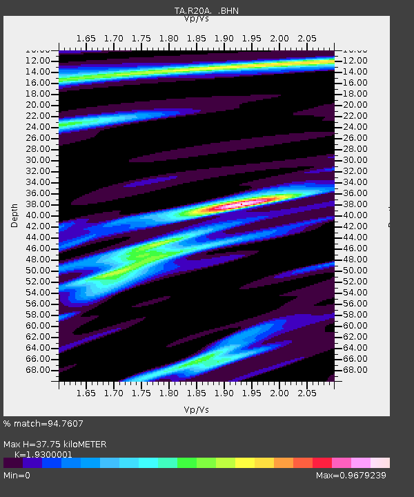
R20A Redvale, CO, USA - Earthquake Result Viewer
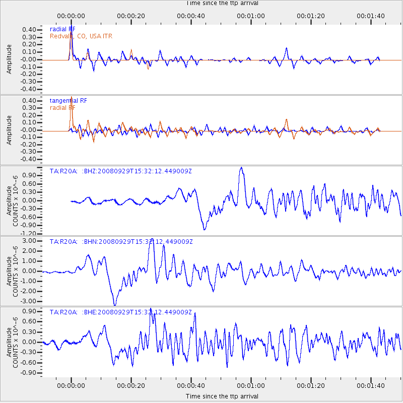
Earthquake location: Kermadec Islands, New Zealand
Earthquake latitude/longitude: -29.8/-177.7
Earthquake time(UTC): 2008/09/29 (273) 15:19:31 GMT
Earthquake Depth: 36 km
Earthquake Magnitude: 6.5 MB, 6.7 MS, 7.0 MW, 7.0 MW
Earthquake Catalog/Contributor: WHDF/NEIC
Network: TA USArray Transportable Network (new EarthScope stations)
Station: R20A Redvale, CO, USA
Lat/Lon: 38.19 N/108.38 W
Elevation: 2003 m
Distance: 93.5 deg
Az: 47.608 deg
Baz: 234.59 deg
Ray Param: 0.04122673
Estimated Moho Depth: 37.75 km
Estimated Crust Vp/Vs: 1.93
Assumed Crust Vp: 6.291 km/s
Estimated Crust Vs: 3.259 km/s
Estimated Crust Poisson's Ratio: 0.32
Radial Match: 94.7607 %
Radial Bump: 351
Transverse Match: 81.28759 %
Transverse Bump: 400
SOD ConfigId: 2560
Insert Time: 2010-03-06 12:26:04.226 +0000
GWidth: 2.5
Max Bumps: 400
Tol: 0.001

Signal To Noise

ChannelStoNSTALTA
TA:R20A: :BHN:20080929T15:32:12.449009Z6.16691163.857599E-76.255318E-8
TA:R20A: :BHE:20080929T15:32:12.449009Z1.43385149.811058E-86.842451E-8
TA:R20A: :BHZ:20080929T15:32:12.449009Z1.70739221.1980819E-77.017028E-8
Arrivals
Ps5.7 SECOND
PpPs17 SECOND
PsPs/PpSs23 SECOND