You are here: Home > Network List > TA - USArray Transportable Network (new EarthScope stations) Stations List
> Station I26K Coal Creek Mining Camp, AK, USA > Earthquake Result Viewer
I26K Coal Creek Mining Camp, AK, USA - Earthquake Result Viewer
| Earthquake location: |
Near East Coast Of Kamchatka |
| Earthquake latitude/longitude: |
51.6/157.9 |
| Earthquake time(UTC): |
2018/07/06 (187) 01:40:08 GMT |
| Earthquake Depth: |
80 km |
| Earthquake Magnitude: |
6.1 Mwp |
| Earthquake Catalog/Contributor: |
NEIC PDE/us |
|
| Network: |
TA USArray Transportable Network (new EarthScope stations) |
| Station: |
I26K Coal Creek Mining Camp, AK, USA |
| Lat/Lon: |
65.31 N/143.15 W |
| Elevation: |
338 m |
|
| Distance: |
32.4 deg |
| Az: |
42.231 deg |
| Baz: |
273.952 deg |
| Ray Param: |
0.07847473 |
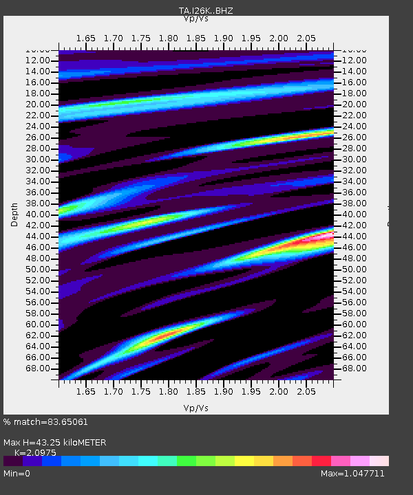
| Estimated Moho Depth: |
43.25 km |
| Estimated Crust Vp/Vs: |
2.10 |
| Assumed Crust Vp: |
6.566 km/s |
| Estimated Crust Vs: |
3.13 km/s |
| Estimated Crust Poisson's Ratio: |
0.35 |
|
| Radial Match: |
83.65061 % |
| Radial Bump: |
400 |
| Transverse Match: |
58.361767 % |
| Transverse Bump: |
400 |
| SOD ConfigId: |
13570011 |
| Insert Time: |
2019-04-30 12:42:38.925 +0000 |
| GWidth: |
2.5 |
| Max Bumps: |
400 |
| Tol: |
0.001 |
|

Signal To Noise
| Channel | StoN | STA | LTA |
| TA:I26K: :BHZ:20180706T01:46:00.57501Z | 3.3892488 | 1.8985298E-7 | 5.601624E-8 |
| TA:I26K: :BHN:20180706T01:46:00.57501Z | 2.3425968 | 8.86071E-8 | 3.7824307E-8 |
| TA:I26K: :BHE:20180706T01:46:00.57501Z | 2.7141178 | 1.6001702E-7 | 5.895729E-8 |
| Arrivals |
| Ps | 7.7 SECOND |
| PpPs | 19 SECOND |
| PsPs/PpSs | 27 SECOND |


