You are here: Home > Network List > TA - USArray Transportable Network (new EarthScope stations) Stations List
> Station R20A Redvale, CO, USA > Earthquake Result Viewer
R20A Redvale, CO, USA - Earthquake Result Viewer
| Earthquake location: |
East Of Kuril Islands |
| Earthquake latitude/longitude: |
46.9/155.2 |
| Earthquake time(UTC): |
2009/01/15 (015) 17:49:39 GMT |
| Earthquake Depth: |
36 km |
| Earthquake Magnitude: |
6.9 MB, 7.5 MS, 7.4 MW, 7.4 MW |
| Earthquake Catalog/Contributor: |
WHDF/NEIC |
|
| Network: |
TA USArray Transportable Network (new EarthScope stations) |
| Station: |
R20A Redvale, CO, USA |
| Lat/Lon: |
38.19 N/108.38 W |
| Elevation: |
2003 m |
|
| Distance: |
67.2 deg |
| Az: |
58.115 deg |
| Baz: |
312.312 deg |
| Ray Param: |
0.05702819 |
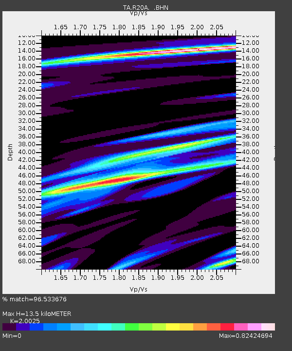
| Estimated Moho Depth: |
13.5 km |
| Estimated Crust Vp/Vs: |
2.00 |
| Assumed Crust Vp: |
6.291 km/s |
| Estimated Crust Vs: |
3.141 km/s |
| Estimated Crust Poisson's Ratio: |
0.33 |
|
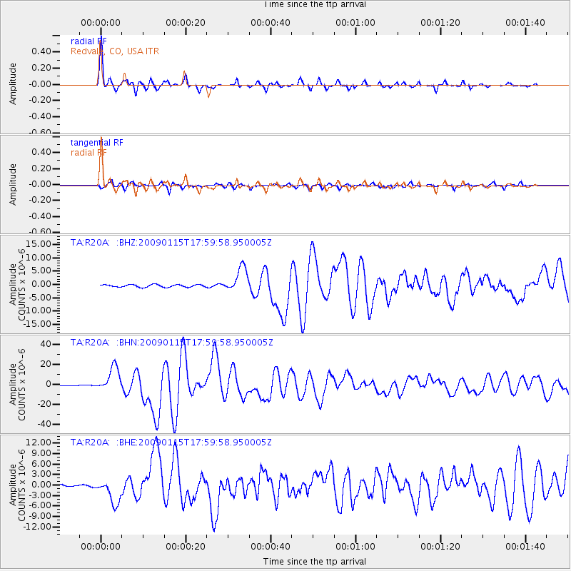
| Radial Match: |
96.533676 % |
| Radial Bump: |
311 |
| Transverse Match: |
90.15241 % |
| Transverse Bump: |
400 |
| SOD ConfigId: |
2834 |
| Insert Time: |
2010-03-06 12:26:11.365 +0000 |
| GWidth: |
2.5 |
| Max Bumps: |
400 |
| Tol: |
0.001 |
|
Signal To Noise
| Channel | StoN | STA | LTA |
| TA:R20A: :BHN:20090115T17:59:58.950005Z | 34.42733 | 1.2714595E-5 | 3.693169E-7 |
| TA:R20A: :BHE:20090115T17:59:58.950005Z | 11.186852 | 3.6213055E-6 | 3.2371085E-7 |
| TA:R20A: :BHZ:20090115T17:59:58.950005Z | 10.3281145 | 4.776499E-6 | 4.624754E-7 |
| Arrivals |
| Ps | 2.2 SECOND |
| PpPs | 6.2 SECOND |
| PsPs/PpSs | 8.5 SECOND |


