You are here: Home > Network List > TA - USArray Transportable Network (new EarthScope stations) Stations List
> Station KMSC Kings Mountain, Blacksburg, SC, USA > Earthquake Result Viewer
KMSC Kings Mountain, Blacksburg, SC, USA - Earthquake Result Viewer
| Earthquake location: |
Near East Coast Of Kamchatka |
| Earthquake latitude/longitude: |
51.6/157.9 |
| Earthquake time(UTC): |
2018/07/06 (187) 01:40:08 GMT |
| Earthquake Depth: |
80 km |
| Earthquake Magnitude: |
6.1 Mwp |
| Earthquake Catalog/Contributor: |
NEIC PDE/us |
|
| Network: |
TA USArray Transportable Network (new EarthScope stations) |
| Station: |
KMSC Kings Mountain, Blacksburg, SC, USA |
| Lat/Lon: |
35.14 N/81.33 W |
| Elevation: |
240 m |
|
| Distance: |
79.3 deg |
| Az: |
45.757 deg |
| Baz: |
326.972 deg |
| Ray Param: |
0.048907746 |
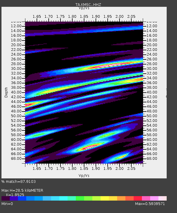
| Estimated Moho Depth: |
28.5 km |
| Estimated Crust Vp/Vs: |
1.95 |
| Assumed Crust Vp: |
6.419 km/s |
| Estimated Crust Vs: |
3.288 km/s |
| Estimated Crust Poisson's Ratio: |
0.32 |
|
| Radial Match: |
87.9103 % |
| Radial Bump: |
400 |
| Transverse Match: |
76.86667 % |
| Transverse Bump: |
400 |
| SOD ConfigId: |
13570011 |
| Insert Time: |
2019-04-30 12:42:48.238 +0000 |
| GWidth: |
2.5 |
| Max Bumps: |
400 |
| Tol: |
0.001 |
|

Signal To Noise
| Channel | StoN | STA | LTA |
| TA:KMSC: :HHZ:20180706T01:51:34.659971Z | 20.016155 | 1.1550972E-6 | 5.770824E-8 |
| TA:KMSC: :HHN:20180706T01:51:34.659971Z | 10.557609 | 4.9148815E-7 | 4.655298E-8 |
| TA:KMSC: :HHE:20180706T01:51:34.659971Z | 5.833855 | 2.8470748E-7 | 4.8802633E-8 |
| Arrivals |
| Ps | 4.3 SECOND |
| PpPs | 13 SECOND |
| PsPs/PpSs | 17 SECOND |


