You are here: Home > Network List > TA - USArray Transportable Network (new EarthScope stations) Stations List
> Station L26K Log Cabin Wilderness Lodge, Tok, AK, USA > Earthquake Result Viewer
L26K Log Cabin Wilderness Lodge, Tok, AK, USA - Earthquake Result Viewer
| Earthquake location: |
Near East Coast Of Kamchatka |
| Earthquake latitude/longitude: |
51.6/157.9 |
| Earthquake time(UTC): |
2018/07/06 (187) 01:40:08 GMT |
| Earthquake Depth: |
80 km |
| Earthquake Magnitude: |
6.1 Mwp |
| Earthquake Catalog/Contributor: |
NEIC PDE/us |
|
| Network: |
TA USArray Transportable Network (new EarthScope stations) |
| Station: |
L26K Log Cabin Wilderness Lodge, Tok, AK, USA |
| Lat/Lon: |
63.03 N/143.35 W |
| Elevation: |
650 m |
|
| Distance: |
32.5 deg |
| Az: |
46.493 deg |
| Baz: |
277.375 deg |
| Ray Param: |
0.078412056 |
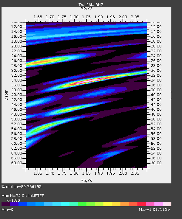
| Estimated Moho Depth: |
34.0 km |
| Estimated Crust Vp/Vs: |
1.86 |
| Assumed Crust Vp: |
6.566 km/s |
| Estimated Crust Vs: |
3.53 km/s |
| Estimated Crust Poisson's Ratio: |
0.30 |
|
| Radial Match: |
80.756195 % |
| Radial Bump: |
400 |
| Transverse Match: |
70.55703 % |
| Transverse Bump: |
400 |
| SOD ConfigId: |
13570011 |
| Insert Time: |
2019-04-30 12:42:49.462 +0000 |
| GWidth: |
2.5 |
| Max Bumps: |
400 |
| Tol: |
0.001 |
|

Signal To Noise
| Channel | StoN | STA | LTA |
| TA:L26K: :BHZ:20180706T01:46:01.774991Z | 15.1247 | 7.045436E-7 | 4.658232E-8 |
| TA:L26K: :BHN:20180706T01:46:01.774991Z | 5.464686 | 1.8033793E-7 | 3.3000603E-8 |
| TA:L26K: :BHE:20180706T01:46:01.774991Z | 13.218559 | 4.5558326E-7 | 3.4465426E-8 |
| Arrivals |
| Ps | 4.8 SECOND |
| PpPs | 14 SECOND |
| PsPs/PpSs | 19 SECOND |


