You are here: Home > Network List > TA - USArray Transportable Network (new EarthScope stations) Stations List
> Station R20A Redvale, CO, USA > Earthquake Result Viewer
R20A Redvale, CO, USA - Earthquake Result Viewer
| Earthquake location: |
Near S. Coast Of Honshu, Japan |
| Earthquake latitude/longitude: |
33.2/137.9 |
| Earthquake time(UTC): |
2009/08/09 (221) 10:55:55 GMT |
| Earthquake Depth: |
297 km |
| Earthquake Magnitude: |
6.5 MB, 7.1 MW, 7.1 MW |
| Earthquake Catalog/Contributor: |
WHDF/NEIC |
|
| Network: |
TA USArray Transportable Network (new EarthScope stations) |
| Station: |
R20A Redvale, CO, USA |
| Lat/Lon: |
38.19 N/108.38 W |
| Elevation: |
2003 m |
|
| Distance: |
86.0 deg |
| Az: |
46.337 deg |
| Baz: |
309.645 deg |
| Ray Param: |
0.043625332 |
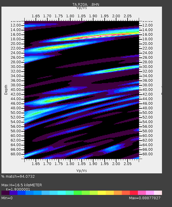
| Estimated Moho Depth: |
16.5 km |
| Estimated Crust Vp/Vs: |
1.93 |
| Assumed Crust Vp: |
6.291 km/s |
| Estimated Crust Vs: |
3.259 km/s |
| Estimated Crust Poisson's Ratio: |
0.32 |
|
| Radial Match: |
94.0732 % |
| Radial Bump: |
400 |
| Transverse Match: |
84.93484 % |
| Transverse Bump: |
400 |
| SOD ConfigId: |
2622 |
| Insert Time: |
2010-03-06 12:26:20.382 +0000 |
| GWidth: |
2.5 |
| Max Bumps: |
400 |
| Tol: |
0.001 |
|
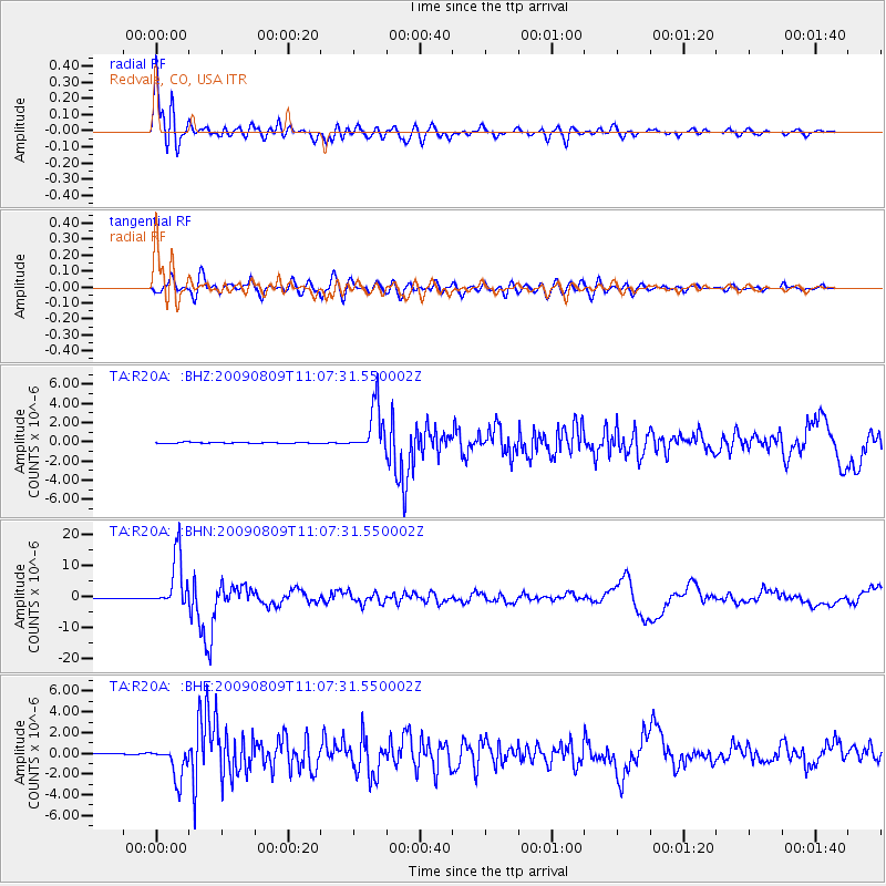
Signal To Noise
| Channel | StoN | STA | LTA |
| TA:R20A: :BHN:20090809T11:07:31.550002Z | 78.30022 | 8.552484E-6 | 1.0922683E-7 |
| TA:R20A: :BHE:20090809T11:07:31.550002Z | 23.710123 | 1.6234642E-6 | 6.847135E-8 |
| TA:R20A: :BHZ:20090809T11:07:31.550002Z | 46.87849 | 2.4716933E-6 | 5.2725525E-8 |
| Arrivals |
| Ps | 2.5 SECOND |
| PpPs | 7.5 SECOND |
| PsPs/PpSs | 10 SECOND |


