You are here: Home > Network List > TA - USArray Transportable Network (new EarthScope stations) Stations List
> Station M26K Nabesna, AK, USA > Earthquake Result Viewer
M26K Nabesna, AK, USA - Earthquake Result Viewer
| Earthquake location: |
Near East Coast Of Kamchatka |
| Earthquake latitude/longitude: |
51.6/157.9 |
| Earthquake time(UTC): |
2018/07/06 (187) 01:40:08 GMT |
| Earthquake Depth: |
80 km |
| Earthquake Magnitude: |
6.1 Mwp |
| Earthquake Catalog/Contributor: |
NEIC PDE/us |
|
| Network: |
TA USArray Transportable Network (new EarthScope stations) |
| Station: |
M26K Nabesna, AK, USA |
| Lat/Lon: |
62.40 N/143.00 W |
| Elevation: |
888 m |
|
| Distance: |
32.8 deg |
| Az: |
47.601 deg |
| Baz: |
278.62 deg |
| Ray Param: |
0.07829787 |
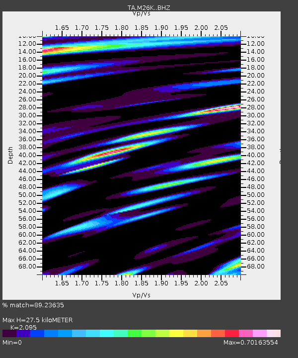
| Estimated Moho Depth: |
27.5 km |
| Estimated Crust Vp/Vs: |
2.10 |
| Assumed Crust Vp: |
6.566 km/s |
| Estimated Crust Vs: |
3.134 km/s |
| Estimated Crust Poisson's Ratio: |
0.35 |
|
| Radial Match: |
89.23635 % |
| Radial Bump: |
400 |
| Transverse Match: |
75.29731 % |
| Transverse Bump: |
400 |
| SOD ConfigId: |
13570011 |
| Insert Time: |
2019-04-30 12:42:55.622 +0000 |
| GWidth: |
2.5 |
| Max Bumps: |
400 |
| Tol: |
0.001 |
|

Signal To Noise
| Channel | StoN | STA | LTA |
| TA:M26K: :BHZ:20180706T01:46:03.899991Z | 42.007942 | 2.2815607E-6 | 5.4312604E-8 |
| TA:M26K: :BHN:20180706T01:46:03.899991Z | 21.639837 | 6.761779E-7 | 3.1246902E-8 |
| TA:M26K: :BHE:20180706T01:46:03.899991Z | 26.586578 | 1.2058157E-6 | 4.53543E-8 |
| Arrivals |
| Ps | 4.9 SECOND |
| PpPs | 12 SECOND |
| PsPs/PpSs | 17 SECOND |


