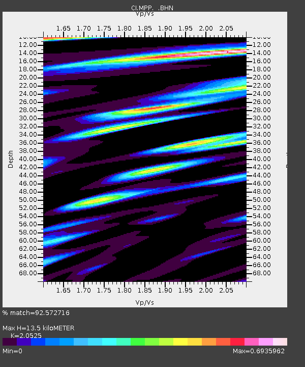
MPP McPhearson Peak - Earthquake Result Viewer
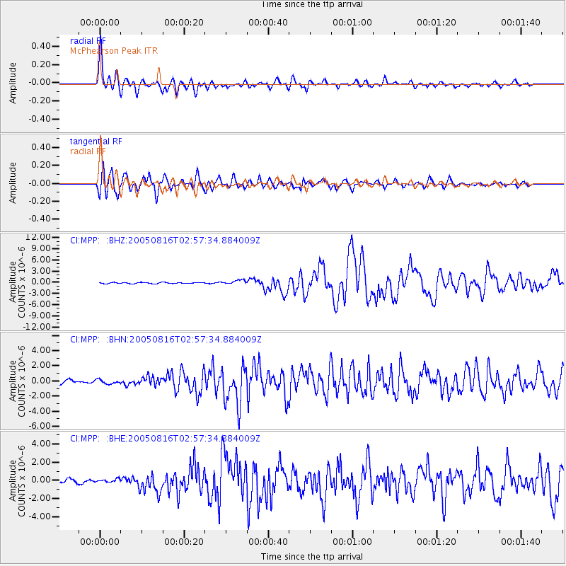
Earthquake location: Near East Coast Of Honshu, Japan
Earthquake latitude/longitude: 38.3/142.0
Earthquake time(UTC): 2005/08/16 (228) 02:46:28 GMT
Earthquake Depth: 36 km
Earthquake Magnitude: 6.5 MB, 6.8 MS, 7.2 MW, 7.1 MW
Earthquake Catalog/Contributor: WHDF/NEIC
Network: CI Caltech Regional Seismic Network
Station: MPP McPhearson Peak
Lat/Lon: 34.89 N/119.81 W
Elevation: 1739 m
Distance: 75.0 deg
Az: 57.421 deg
Baz: 306.22 deg
Ray Param: 0.051932506
Estimated Moho Depth: 13.5 km
Estimated Crust Vp/Vs: 2.05
Assumed Crust Vp: 6.1 km/s
Estimated Crust Vs: 2.972 km/s
Estimated Crust Poisson's Ratio: 0.34
Radial Match: 92.572716 %
Radial Bump: 400
Transverse Match: 87.2872 %
Transverse Bump: 400
SOD ConfigId: 2475
Insert Time: 2010-02-26 02:04:00.476 +0000
GWidth: 2.5
Max Bumps: 400
Tol: 0.001

Signal To Noise

ChannelStoNSTALTA
CI:MPP: :BHN:20050816T02:57:34.884009Z1.17873482.7885574E-72.3657209E-7
CI:MPP: :BHE:20050816T02:57:34.884009Z0.848886972.0085476E-72.3660955E-7
CI:MPP: :BHZ:20050816T02:57:34.884009Z3.8491755.6752697E-71.474412E-7
Arrivals
Ps2.4 SECOND
PpPs6.6 SECOND
PsPs/PpSs9.0 SECOND