You are here: Home > Network List > TA - USArray Transportable Network (new EarthScope stations) Stations List
> Station O28M Mount Upton, YT, CAN > Earthquake Result Viewer
O28M Mount Upton, YT, CAN - Earthquake Result Viewer

| Earthquake location: |
Near East Coast Of Kamchatka |
| Earthquake latitude/longitude: |
51.6/157.9 |
| Earthquake time(UTC): |
2018/07/06 (187) 01:40:08 GMT |
| Earthquake Depth: |
80 km |
| Earthquake Magnitude: |
6.1 Mwp |
| Earthquake Catalog/Contributor: |
NEIC PDE/us |
|
| Network: |
TA USArray Transportable Network (new EarthScope stations) |
| Station: |
O28M Mount Upton, YT, CAN |
| Lat/Lon: |
60.77 N/140.19 W |
| Elevation: |
2622 m |
|
| Distance: |
34.4 deg |
| Az: |
50.046 deg |
| Baz: |
283.121 deg |
| Ray Param: |
0.07752286 |
| Estimated Moho Depth: |
22.25 km |
| Estimated Crust Vp/Vs: |
2.10 |
| Assumed Crust Vp: |
6.566 km/s |
| Estimated Crust Vs: |
3.13 km/s |
| Estimated Crust Poisson's Ratio: |
0.35 |
|
| Radial Match: |
89.236 % |
| Radial Bump: |
400 |
| Transverse Match: |
83.30282 % |
| Transverse Bump: |
400 |
| SOD ConfigId: |
13570011 |
| Insert Time: |
2019-04-30 12:43:05.698 +0000 |
| GWidth: |
2.5 |
| Max Bumps: |
400 |
| Tol: |
0.001 |
|
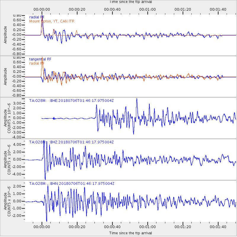
Signal To Noise
| Channel | StoN | STA | LTA |
| TA:O28M: :BHZ:20180706T01:46:17.975004Z | 49.74815 | 2.7019048E-6 | 5.4311666E-8 |
| TA:O28M: :BHN:20180706T01:46:17.975004Z | 26.127083 | 9.891127E-7 | 3.7857752E-8 |
| TA:O28M: :BHE:20180706T01:46:17.975004Z | 23.13505 | 1.2264278E-6 | 5.301168E-8 |
| Arrivals |
| Ps | 4.0 SECOND |
| PpPs | 9.8 SECOND |
| PsPs/PpSs | 14 SECOND |


