You are here: Home > Network List > TA - USArray Transportable Network (new EarthScope stations) Stations List
> Station R20A Redvale, CO, USA > Earthquake Result Viewer
R20A Redvale, CO, USA - Earthquake Result Viewer
| Earthquake location: |
Off Coast Of Costa Rica |
| Earthquake latitude/longitude: |
7.9/-85.6 |
| Earthquake time(UTC): |
2009/08/13 (225) 09:37:35 GMT |
| Earthquake Depth: |
10 km |
| Earthquake Magnitude: |
5.8 MW, 5.3 MB |
| Earthquake Catalog/Contributor: |
WHDF/NEIC |
|
| Network: |
TA USArray Transportable Network (new EarthScope stations) |
| Station: |
R20A Redvale, CO, USA |
| Lat/Lon: |
38.19 N/108.38 W |
| Elevation: |
2003 m |
|
| Distance: |
36.4 deg |
| Az: |
329.147 deg |
| Baz: |
139.861 deg |
| Ray Param: |
0.07667491 |
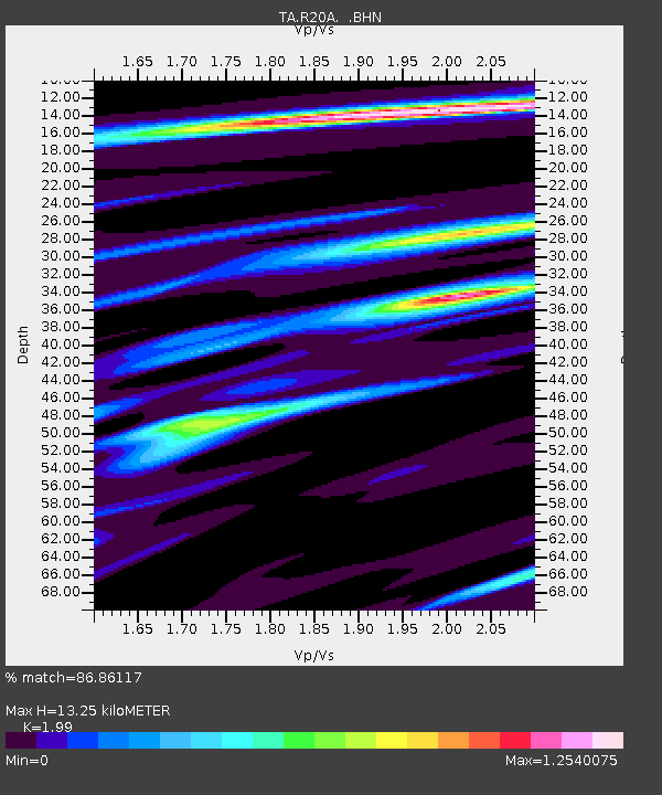
| Estimated Moho Depth: |
13.25 km |
| Estimated Crust Vp/Vs: |
1.99 |
| Assumed Crust Vp: |
6.291 km/s |
| Estimated Crust Vs: |
3.161 km/s |
| Estimated Crust Poisson's Ratio: |
0.33 |
|
| Radial Match: |
86.86117 % |
| Radial Bump: |
288 |
| Transverse Match: |
69.76616 % |
| Transverse Bump: |
400 |
| SOD ConfigId: |
2622 |
| Insert Time: |
2010-03-06 12:26:27.921 +0000 |
| GWidth: |
2.5 |
| Max Bumps: |
400 |
| Tol: |
0.001 |
|
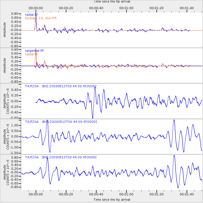
Signal To Noise
| Channel | StoN | STA | LTA |
| TA:R20A: :BHN:20090813T09:44:09.450006Z | 4.089711 | 3.4566403E-7 | 8.452041E-8 |
| TA:R20A: :BHE:20090813T09:44:09.450006Z | 3.9526575 | 1.5811773E-7 | 4.000289E-8 |
| TA:R20A: :BHZ:20090813T09:44:09.450006Z | 3.3163855 | 1.4241553E-7 | 4.2942997E-8 |
| Arrivals |
| Ps | 2.2 SECOND |
| PpPs | 5.9 SECOND |
| PsPs/PpSs | 8.1 SECOND |


