You are here: Home > Network List > TA - USArray Transportable Network (new EarthScope stations) Stations List
> Station R33M Jennings River, BC, CAN > Earthquake Result Viewer
R33M Jennings River, BC, CAN - Earthquake Result Viewer
| Earthquake location: |
Near East Coast Of Kamchatka |
| Earthquake latitude/longitude: |
51.6/157.9 |
| Earthquake time(UTC): |
2018/07/06 (187) 01:40:08 GMT |
| Earthquake Depth: |
80 km |
| Earthquake Magnitude: |
6.1 Mwp |
| Earthquake Catalog/Contributor: |
NEIC PDE/us |
|
| Network: |
TA USArray Transportable Network (new EarthScope stations) |
| Station: |
R33M Jennings River, BC, CAN |
| Lat/Lon: |
59.39 N/130.97 W |
| Elevation: |
1437 m |
|
| Distance: |
39.2 deg |
| Az: |
49.979 deg |
| Baz: |
291.053 deg |
| Ray Param: |
0.07485713 |
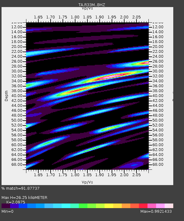
| Estimated Moho Depth: |
26.25 km |
| Estimated Crust Vp/Vs: |
2.10 |
| Assumed Crust Vp: |
6.597 km/s |
| Estimated Crust Vs: |
3.145 km/s |
| Estimated Crust Poisson's Ratio: |
0.35 |
|
| Radial Match: |
91.87737 % |
| Radial Bump: |
373 |
| Transverse Match: |
81.52641 % |
| Transverse Bump: |
400 |
| SOD ConfigId: |
13570011 |
| Insert Time: |
2019-04-30 12:43:20.142 +0000 |
| GWidth: |
2.5 |
| Max Bumps: |
400 |
| Tol: |
0.001 |
|

Signal To Noise
| Channel | StoN | STA | LTA |
| TA:R33M: :BHZ:20180706T01:46:58.850004Z | 56.864746 | 2.2971171E-6 | 4.0396156E-8 |
| TA:R33M: :BHN:20180706T01:46:58.850004Z | 23.838057 | 8.591975E-7 | 3.60431E-8 |
| TA:R33M: :BHE:20180706T01:46:58.850004Z | 35.841537 | 1.3025239E-6 | 3.634118E-8 |
| Arrivals |
| Ps | 4.7 SECOND |
| PpPs | 12 SECOND |
| PsPs/PpSs | 16 SECOND |


