You are here: Home > Network List > TA - USArray Transportable Network (new EarthScope stations) Stations List
> Station TPFO Pinon Flats, CA, USA > Earthquake Result Viewer
TPFO Pinon Flats, CA, USA - Earthquake Result Viewer
| Earthquake location: |
Near East Coast Of Kamchatka |
| Earthquake latitude/longitude: |
51.6/157.9 |
| Earthquake time(UTC): |
2018/07/06 (187) 01:40:08 GMT |
| Earthquake Depth: |
80 km |
| Earthquake Magnitude: |
6.1 Mwp |
| Earthquake Catalog/Contributor: |
NEIC PDE/us |
|
| Network: |
TA USArray Transportable Network (new EarthScope stations) |
| Station: |
TPFO Pinon Flats, CA, USA |
| Lat/Lon: |
33.61 N/116.45 W |
| Elevation: |
1275 m |
|
| Distance: |
62.0 deg |
| Az: |
70.513 deg |
| Baz: |
315.224 deg |
| Ray Param: |
0.060317893 |
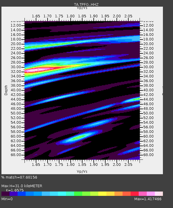
| Estimated Moho Depth: |
31.0 km |
| Estimated Crust Vp/Vs: |
1.66 |
| Assumed Crust Vp: |
6.264 km/s |
| Estimated Crust Vs: |
3.779 km/s |
| Estimated Crust Poisson's Ratio: |
0.21 |
|
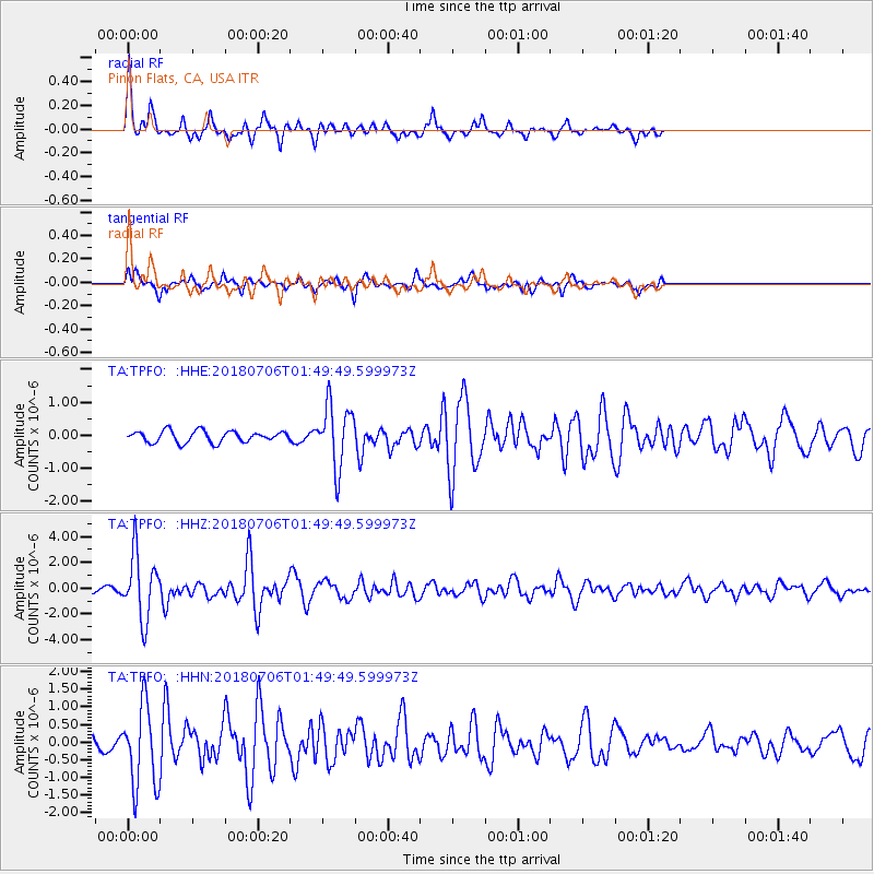
| Radial Match: |
87.68156 % |
| Radial Bump: |
309 |
| Transverse Match: |
55.509914 % |
| Transverse Bump: |
350 |
| SOD ConfigId: |
13570011 |
| Insert Time: |
2019-04-30 12:43:28.086 +0000 |
| GWidth: |
2.5 |
| Max Bumps: |
400 |
| Tol: |
0.001 |
|
Signal To Noise
| Channel | StoN | STA | LTA |
| TA:TPFO: :HHZ:20180706T01:49:49.599973Z | 15.922974 | 2.4986211E-6 | 1.5691926E-7 |
| TA:TPFO: :HHN:20180706T01:49:49.599973Z | 7.937347 | 1.158021E-6 | 1.4589521E-7 |
| TA:TPFO: :HHE:20180706T01:49:49.599973Z | 5.387961 | 9.344486E-7 | 1.7343271E-7 |
| Arrivals |
| Ps | 3.4 SECOND |
| PpPs | 13 SECOND |
| PsPs/PpSs | 16 SECOND |


