You are here: Home > Network List > TD - TransAlta Monitoring Network Stations List
> Station TD008 Z > Earthquake Result Viewer
TD008 Z - Earthquake Result Viewer
| Earthquake location: |
Near East Coast Of Kamchatka |
| Earthquake latitude/longitude: |
51.6/157.9 |
| Earthquake time(UTC): |
2018/07/06 (187) 01:40:08 GMT |
| Earthquake Depth: |
80 km |
| Earthquake Magnitude: |
6.1 Mwp |
| Earthquake Catalog/Contributor: |
NEIC PDE/us |
|
| Network: |
TD TransAlta Monitoring Network |
| Station: |
TD008 Z |
| Lat/Lon: |
52.80 N/115.43 W |
| Elevation: |
964 m |
|
| Distance: |
50.0 deg |
| Az: |
52.312 deg |
| Baz: |
305.635 deg |
| Ray Param: |
0.06810617 |
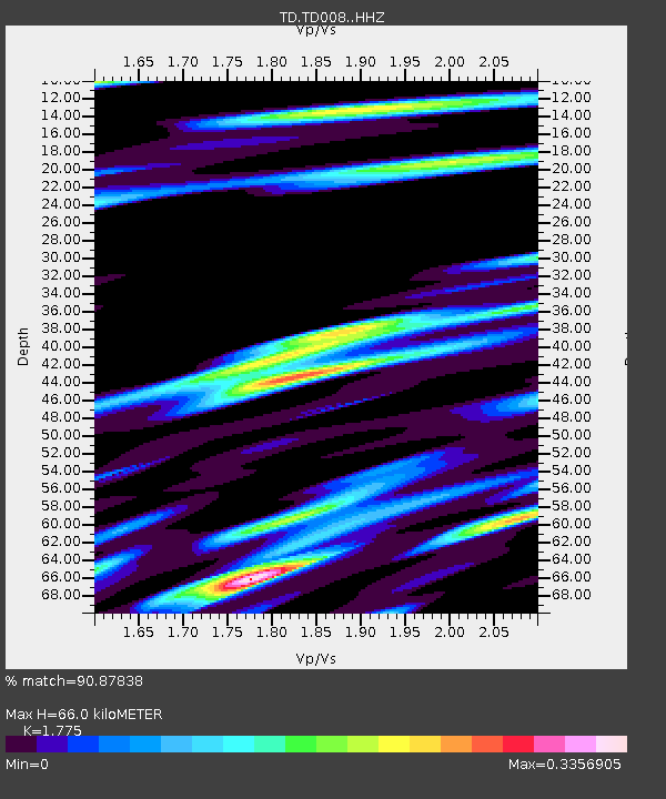
| Estimated Moho Depth: |
66.0 km |
| Estimated Crust Vp/Vs: |
1.77 |
| Assumed Crust Vp: |
6.426 km/s |
| Estimated Crust Vs: |
3.62 km/s |
| Estimated Crust Poisson's Ratio: |
0.27 |
|
| Radial Match: |
90.87838 % |
| Radial Bump: |
400 |
| Transverse Match: |
82.08255 % |
| Transverse Bump: |
400 |
| SOD ConfigId: |
13570011 |
| Insert Time: |
2019-04-30 12:43:37.048 +0000 |
| GWidth: |
2.5 |
| Max Bumps: |
400 |
| Tol: |
0.001 |
|

Signal To Noise
| Channel | StoN | STA | LTA |
| TD:TD008: :HHZ:20180706T01:48:24.360013Z | 59.150345 | 4.5607626E-6 | 7.710459E-8 |
| TD:TD008: :HH1:20180706T01:48:24.360013Z | 12.881047 | 9.203215E-7 | 7.144772E-8 |
| TD:TD008: :HH2:20180706T01:48:24.360013Z | 19.561026 | 1.5260911E-6 | 7.8016924E-8 |
| Arrivals |
| Ps | 8.4 SECOND |
| PpPs | 27 SECOND |
| PsPs/PpSs | 35 SECOND |


