You are here: Home > Network List > TJ - Tajikistan National Seismic Network Stations List
> Station SHAA Shaartuz, Tajikistan > Earthquake Result Viewer
SHAA Shaartuz, Tajikistan - Earthquake Result Viewer
| Earthquake location: |
Near East Coast Of Kamchatka |
| Earthquake latitude/longitude: |
51.6/157.9 |
| Earthquake time(UTC): |
2018/07/06 (187) 01:40:08 GMT |
| Earthquake Depth: |
80 km |
| Earthquake Magnitude: |
6.1 Mwp |
| Earthquake Catalog/Contributor: |
NEIC PDE/us |
|
| Network: |
TJ Tajikistan National Seismic Network |
| Station: |
SHAA Shaartuz, Tajikistan |
| Lat/Lon: |
37.56 N/68.12 E |
| Elevation: |
868 m |
|
| Distance: |
61.5 deg |
| Az: |
295.298 deg |
| Baz: |
45.186 deg |
| Ray Param: |
0.06061958 |
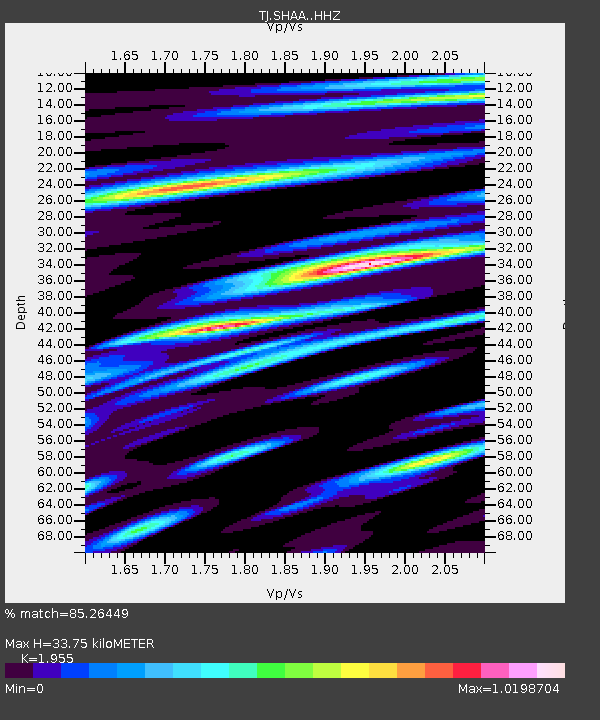
| Estimated Moho Depth: |
33.75 km |
| Estimated Crust Vp/Vs: |
1.96 |
| Assumed Crust Vp: |
6.213 km/s |
| Estimated Crust Vs: |
3.178 km/s |
| Estimated Crust Poisson's Ratio: |
0.32 |
|
| Radial Match: |
85.26449 % |
| Radial Bump: |
400 |
| Transverse Match: |
82.24208 % |
| Transverse Bump: |
400 |
| SOD ConfigId: |
13570011 |
| Insert Time: |
2019-04-30 12:43:44.934 +0000 |
| GWidth: |
2.5 |
| Max Bumps: |
400 |
| Tol: |
0.001 |
|
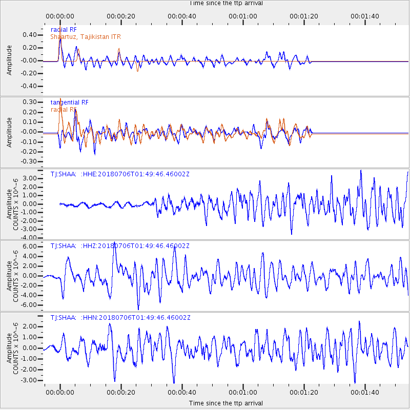
Signal To Noise
| Channel | StoN | STA | LTA |
| TJ:SHAA: :HHZ:20180706T01:49:46.46002Z | 14.918279 | 2.300692E-6 | 1.5421966E-7 |
| TJ:SHAA: :HHN:20180706T01:49:46.46002Z | 4.368233 | 6.868716E-7 | 1.5724243E-7 |
| TJ:SHAA: :HHE:20180706T01:49:46.46002Z | 3.0706174 | 5.978489E-7 | 1.946999E-7 |
| Arrivals |
| Ps | 5.4 SECOND |
| PpPs | 15 SECOND |
| PsPs/PpSs | 21 SECOND |


