You are here: Home > Network List > TA - USArray Transportable Network (new EarthScope stations) Stations List
> Station R20A Redvale, CO, USA > Earthquake Result Viewer
R20A Redvale, CO, USA - Earthquake Result Viewer
| Earthquake location: |
Galapagos Islands Region |
| Earthquake latitude/longitude: |
2.4/-95.1 |
| Earthquake time(UTC): |
2009/03/15 (074) 03:14:31 GMT |
| Earthquake Depth: |
10 km |
| Earthquake Magnitude: |
5.5 MS, 5.4 MB, 5.8 MW, 5.8 MW |
| Earthquake Catalog/Contributor: |
WHDF/NEIC |
|
| Network: |
TA USArray Transportable Network (new EarthScope stations) |
| Station: |
R20A Redvale, CO, USA |
| Lat/Lon: |
38.19 N/108.38 W |
| Elevation: |
2003 m |
|
| Distance: |
37.6 deg |
| Az: |
342.777 deg |
| Baz: |
157.95 deg |
| Ray Param: |
0.07604462 |
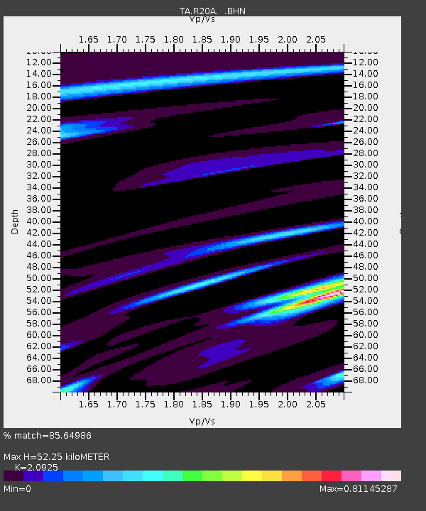
| Estimated Moho Depth: |
52.25 km |
| Estimated Crust Vp/Vs: |
2.09 |
| Assumed Crust Vp: |
6.291 km/s |
| Estimated Crust Vs: |
3.006 km/s |
| Estimated Crust Poisson's Ratio: |
0.35 |
|
| Radial Match: |
85.64986 % |
| Radial Bump: |
251 |
| Transverse Match: |
62.862614 % |
| Transverse Bump: |
400 |
| SOD ConfigId: |
2658 |
| Insert Time: |
2010-03-06 12:26:50.504 +0000 |
| GWidth: |
2.5 |
| Max Bumps: |
400 |
| Tol: |
0.001 |
|
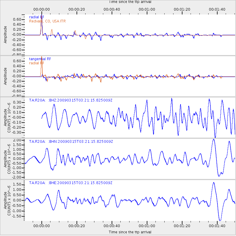
Signal To Noise
| Channel | StoN | STA | LTA |
| TA:R20A: :BHN:20090315T03:21:15.825009Z | 2.686241 | 6.192339E-7 | 2.3052061E-7 |
| TA:R20A: :BHE:20090315T03:21:15.825009Z | 2.4574382 | 3.261429E-7 | 1.3271662E-7 |
| TA:R20A: :BHZ:20090315T03:21:15.825009Z | 0.9585461 | 1.1478663E-7 | 1.1975077E-7 |
| Arrivals |
| Ps | 9.6 SECOND |
| PpPs | 24 SECOND |
| PsPs/PpSs | 34 SECOND |


