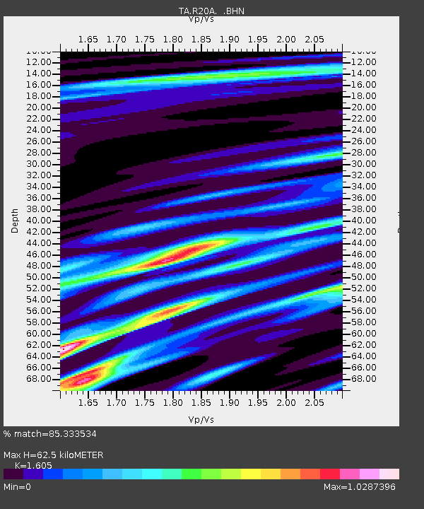
R20A Redvale, CO, USA - Earthquake Result Viewer
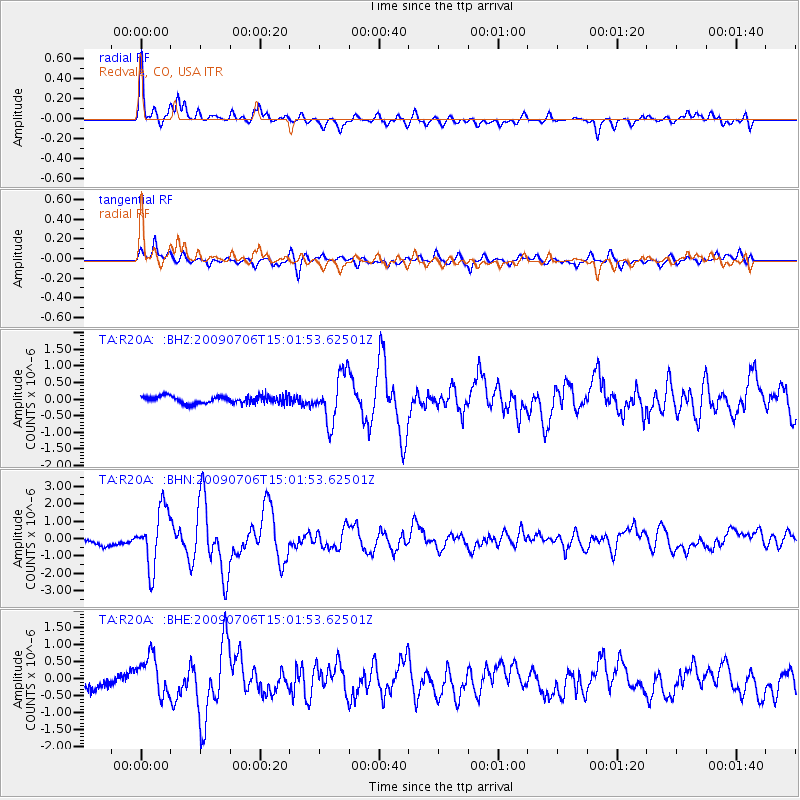
Earthquake location: Rat Islands, Aleutian Islands
Earthquake latitude/longitude: 50.4/177.0
Earthquake time(UTC): 2009/07/06 (187) 14:53:12 GMT
Earthquake Depth: 22 km
Earthquake Magnitude: 6.0 MB, 5.8 MS, 6.1 MW, 6.0 MW
Earthquake Catalog/Contributor: WHDF/NEIC
Network: TA USArray Transportable Network (new EarthScope stations)
Station: R20A Redvale, CO, USA
Lat/Lon: 38.19 N/108.38 W
Elevation: 2003 m
Distance: 52.6 deg
Az: 72.941 deg
Baz: 309.118 deg
Ray Param: 0.066604644
Estimated Moho Depth: 62.5 km
Estimated Crust Vp/Vs: 1.61
Assumed Crust Vp: 6.291 km/s
Estimated Crust Vs: 3.919 km/s
Estimated Crust Poisson's Ratio: 0.18
Radial Match: 85.333534 %
Radial Bump: 400
Transverse Match: 75.48596 %
Transverse Bump: 400
SOD ConfigId: 2648
Insert Time: 2010-03-06 12:26:55.262 +0000
GWidth: 2.5
Max Bumps: 400
Tol: 0.001

Signal To Noise

ChannelStoNSTALTA
TA:R20A: :BHN:20090706T15:01:53.62501Z7.385071.6674478E-62.2578632E-7
TA:R20A: :BHE:20090706T15:01:53.62501Z3.64036975.95827E-71.6367211E-7
TA:R20A: :BHZ:20090706T15:01:53.62501Z6.454097.1944936E-71.1147185E-7
Arrivals
Ps6.4 SECOND
PpPs24 SECOND
PsPs/PpSs31 SECOND