You are here: Home > Network List > UW - Pacific Northwest Regional Seismic Network Stations List
> Station BABR Baber Butte, OR, USA > Earthquake Result Viewer
BABR Baber Butte, OR, USA - Earthquake Result Viewer
| Earthquake location: |
Near East Coast Of Kamchatka |
| Earthquake latitude/longitude: |
51.6/157.9 |
| Earthquake time(UTC): |
2018/07/06 (187) 01:40:08 GMT |
| Earthquake Depth: |
80 km |
| Earthquake Magnitude: |
6.1 Mwp |
| Earthquake Catalog/Contributor: |
NEIC PDE/us |
|
| Network: |
UW Pacific Northwest Regional Seismic Network |
| Station: |
BABR Baber Butte, OR, USA |
| Lat/Lon: |
44.62 N/123.79 W |
| Elevation: |
439 m |
|
| Distance: |
50.4 deg |
| Az: |
65.157 deg |
| Baz: |
307.594 deg |
| Ray Param: |
0.06781605 |
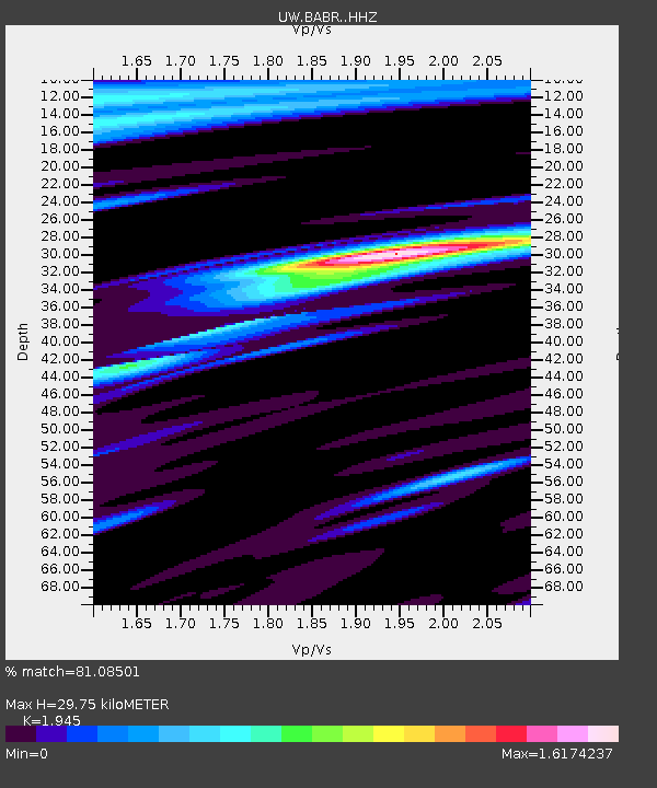
| Estimated Moho Depth: |
29.75 km |
| Estimated Crust Vp/Vs: |
1.95 |
| Assumed Crust Vp: |
6.566 km/s |
| Estimated Crust Vs: |
3.376 km/s |
| Estimated Crust Poisson's Ratio: |
0.32 |
|
| Radial Match: |
81.08501 % |
| Radial Bump: |
400 |
| Transverse Match: |
60.802204 % |
| Transverse Bump: |
400 |
| SOD ConfigId: |
13570011 |
| Insert Time: |
2019-04-30 12:44:26.484 +0000 |
| GWidth: |
2.5 |
| Max Bumps: |
400 |
| Tol: |
0.001 |
|

Signal To Noise
| Channel | StoN | STA | LTA |
| UW:BABR: :HHZ:20180706T01:48:27.459989Z | 14.792038 | 4.2856627E-6 | 2.8972767E-7 |
| UW:BABR: :HHN:20180706T01:48:27.459989Z | 4.1365075 | 9.565489E-7 | 2.3124552E-7 |
| UW:BABR: :HHE:20180706T01:48:27.459989Z | 4.736219 | 1.3375872E-6 | 2.824167E-7 |
| Arrivals |
| Ps | 4.5 SECOND |
| PpPs | 13 SECOND |
| PsPs/PpSs | 17 SECOND |


